You are here: Home > Network List > TA - USArray Transportable Network (new EarthScope stations) Stations List
> Station I23K Minto, Yukon-Koyukuk, AK, USA > Earthquake Result Viewer
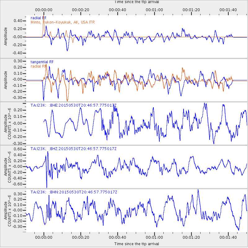
I23K Minto, Yukon-Koyukuk, AK, USA - Earthquake Result Viewer
*The percent match for this event was below the threshold and hence no stack was calculated.
| Earthquake location: |
Tajikistan-Xinjiang Border Reg. |
| Earthquake latitude/longitude: |
38.3/73.0 |
| Earthquake time(UTC): |
2015/05/30 (150) 20:36:16 GMT |
| Earthquake Depth: |
92 km |
| Earthquake Magnitude: |
5.4 mb, 5.4 mb |
| Earthquake Catalog/Contributor: |
ISC/ISC |
|
| Network: |
TA USArray Transportable Network (new EarthScope stations) |
| Station: |
I23K Minto, Yukon-Koyukuk, AK, USA |
| Lat/Lon: |
65.15 N/149.36 W |
| Elevation: |
149 m |
|
| Distance: |
71.7 deg |
| Az: |
17.458 deg |
| Baz: |
326.07 deg |
| Ray Param: |
$rayparam |
*The percent match for this event was below the threshold and hence was not used in the summary stack. |
|
| Radial Match: |
59.569946 % |
| Radial Bump: |
400 |
| Transverse Match: |
70.47599 % |
| Transverse Bump: |
400 |
| SOD ConfigId: |
7422571 |
| Insert Time: |
2019-04-19 03:57:43.426 +0000 |
| GWidth: |
2.5 |
| Max Bumps: |
400 |
| Tol: |
0.001 |
|
Signal To Noise
| Channel | StoN | STA | LTA |
| TA:I23K: :BHZ:20150530T20:46:57.775017Z | 2.5326042 | 2.8210442E-7 | 1.1138907E-7 |
| TA:I23K: :BHN:20150530T20:46:57.775017Z | 1.5631108 | 1.5520652E-7 | 9.929335E-8 |
| TA:I23K: :BHE:20150530T20:46:57.775017Z | 1.4246974 | 1.5858065E-7 | 1.11308296E-7 |
| Arrivals |
| Ps | |
| PpPs | |
| PsPs/PpSs | |


