You are here: Home > Network List > IU - Global Seismograph Network (GSN - IRIS/USGS) Stations List
> Station GNI Garni, Armenia > Earthquake Result Viewer
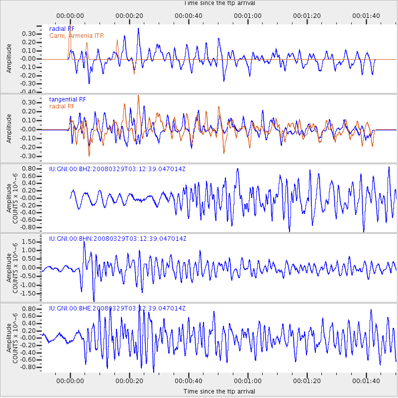
GNI Garni, Armenia - Earthquake Result Viewer
*The percent match for this event was below the threshold and hence no stack was calculated.
| Earthquake location: |
Philippine Islands Region |
| Earthquake latitude/longitude: |
13.3/125.7 |
| Earthquake time(UTC): |
2008/03/29 (089) 03:01:31 GMT |
| Earthquake Depth: |
18 km |
| Earthquake Magnitude: |
5.7 MB, 5.2 MS, 5.7 MW, 5.7 MW |
| Earthquake Catalog/Contributor: |
WHDF/NEIC |
|
| Network: |
IU Global Seismograph Network (GSN - IRIS/USGS) |
| Station: |
GNI Garni, Armenia |
| Lat/Lon: |
40.15 N/44.74 E |
| Elevation: |
1609 m |
|
| Distance: |
74.7 deg |
| Az: |
308.295 deg |
| Baz: |
85.448 deg |
| Ray Param: |
$rayparam |
*The percent match for this event was below the threshold and hence was not used in the summary stack. |
|
| Radial Match: |
76.25695 % |
| Radial Bump: |
400 |
| Transverse Match: |
68.77154 % |
| Transverse Bump: |
400 |
| SOD ConfigId: |
2504 |
| Insert Time: |
2010-03-03 13:57:13.764 +0000 |
| GWidth: |
2.5 |
| Max Bumps: |
400 |
| Tol: |
0.001 |
|
Signal To Noise
| Channel | StoN | STA | LTA |
| IU:GNI:00:BHN:20080329T03:12:39.047014Z | 7.990247 | 5.7940116E-7 | 7.251355E-8 |
| IU:GNI:00:BHE:20080329T03:12:39.047014Z | 1.1771582 | 1.1678968E-7 | 9.921324E-8 |
| IU:GNI:00:BHZ:20080329T03:12:39.047014Z | 0.9454003 | 1.1885623E-7 | 1.2572053E-7 |
| Arrivals |
| Ps | |
| PpPs | |
| PsPs/PpSs | |


