You are here: Home > Network List > IU - Global Seismograph Network (GSN - IRIS/USGS) Stations List
> Station GNI Garni, Armenia > Earthquake Result Viewer
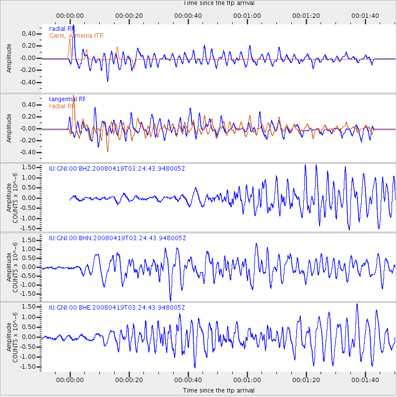
GNI Garni, Armenia - Earthquake Result Viewer
*The percent match for this event was below the threshold and hence no stack was calculated.
| Earthquake location: |
Banda Sea |
| Earthquake latitude/longitude: |
-7.8/125.7 |
| Earthquake time(UTC): |
2008/04/19 (110) 03:12:25 GMT |
| Earthquake Depth: |
13 km |
| Earthquake Magnitude: |
5.8 MB, 5.8 MS, 6.1 MW, 6.1 MW |
| Earthquake Catalog/Contributor: |
WHDF/NEIC |
|
| Network: |
IU Global Seismograph Network (GSN - IRIS/USGS) |
| Station: |
GNI Garni, Armenia |
| Lat/Lon: |
40.15 N/44.74 E |
| Elevation: |
1609 m |
|
| Distance: |
88.1 deg |
| Az: |
310.766 deg |
| Baz: |
101.754 deg |
| Ray Param: |
$rayparam |
*The percent match for this event was below the threshold and hence was not used in the summary stack. |
|
| Radial Match: |
69.67488 % |
| Radial Bump: |
400 |
| Transverse Match: |
69.74974 % |
| Transverse Bump: |
400 |
| SOD ConfigId: |
2504 |
| Insert Time: |
2010-03-03 13:57:40.962 +0000 |
| GWidth: |
2.5 |
| Max Bumps: |
400 |
| Tol: |
0.001 |
|
Signal To Noise
| Channel | StoN | STA | LTA |
| IU:GNI:00:BHN:20080419T03:24:43.948005Z | 2.093725 | 1.5398015E-7 | 7.354364E-8 |
| IU:GNI:00:BHE:20080419T03:24:43.948005Z | 1.1242859 | 8.804892E-8 | 7.8315416E-8 |
| IU:GNI:00:BHZ:20080419T03:24:43.948005Z | 0.8770042 | 7.928406E-8 | 9.040328E-8 |
| Arrivals |
| Ps | |
| PpPs | |
| PsPs/PpSs | |


