You are here: Home > Network List > IU - Global Seismograph Network (GSN - IRIS/USGS) Stations List
> Station GNI Garni, Armenia > Earthquake Result Viewer
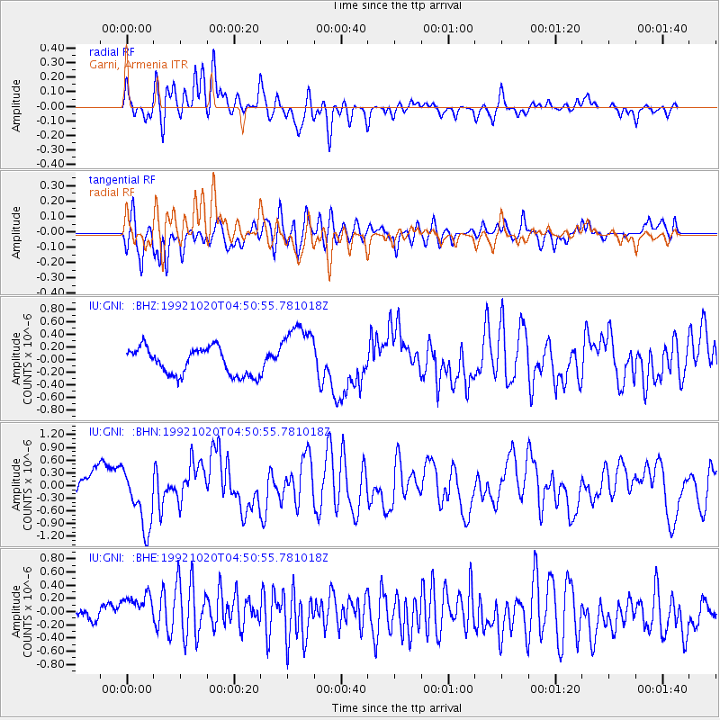
GNI Garni, Armenia - Earthquake Result Viewer
*The percent match for this event was below the threshold and hence no stack was calculated.
| Earthquake location: |
Komandorskiye Ostrova Region |
| Earthquake latitude/longitude: |
55.5/166.4 |
| Earthquake time(UTC): |
1992/10/20 (294) 04:40:02 GMT |
| Earthquake Depth: |
33 km |
| Earthquake Magnitude: |
5.5 MB, 5.8 MS |
| Earthquake Catalog/Contributor: |
WHDF/NEIC |
|
| Network: |
IU Global Seismograph Network (GSN - IRIS/USGS) |
| Station: |
GNI Garni, Armenia |
| Lat/Lon: |
40.15 N/44.74 E |
| Elevation: |
1609 m |
|
| Distance: |
72.6 deg |
| Az: |
316.876 deg |
| Baz: |
30.472 deg |
| Ray Param: |
$rayparam |
*The percent match for this event was below the threshold and hence was not used in the summary stack. |
|
| Radial Match: |
70.07693 % |
| Radial Bump: |
400 |
| Transverse Match: |
64.19018 % |
| Transverse Bump: |
400 |
| SOD ConfigId: |
4480 |
| Insert Time: |
2010-03-03 13:58:24.692 +0000 |
| GWidth: |
2.5 |
| Max Bumps: |
400 |
| Tol: |
0.001 |
|
Signal To Noise
| Channel | StoN | STA | LTA |
| IU:GNI: :BHN:19921020T04:50:55.781018Z | 3.2461069 | 7.2734304E-7 | 2.2406626E-7 |
| IU:GNI: :BHE:19921020T04:50:55.781018Z | 1.701046 | 4.3505474E-7 | 2.557572E-7 |
| IU:GNI: :BHZ:19921020T04:50:55.781018Z | 2.2432148 | 4.8076544E-7 | 2.1431981E-7 |
| Arrivals |
| Ps | |
| PpPs | |
| PsPs/PpSs | |


