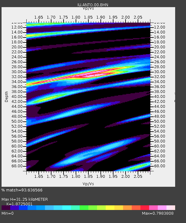
ANTO Ankara, Turkey - Earthquake Result Viewer
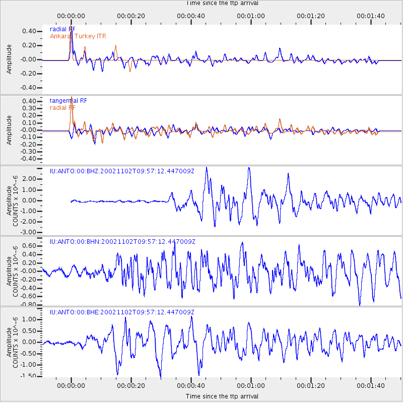
Earthquake location: Northern Sumatra, Indonesia
Earthquake latitude/longitude: 3.0/96.4
Earthquake time(UTC): 2002/11/02 (306) 09:46:46 GMT
Earthquake Depth: 27 km
Earthquake Magnitude: 5.9 MB, 6.4 MS, 6.4 MW, 6.1 MW
Earthquake Catalog/Contributor: WHDF/NEIC
Network: IU Global Seismograph Network (GSN - IRIS/USGS)
Station: ANTO Ankara, Turkey
Lat/Lon: 39.87 N/32.79 E
Elevation: 883 m
Distance: 68.0 deg
Az: 311.974 deg
Baz: 105.265 deg
Ray Param: 0.05654635
Estimated Moho Depth: 31.25 km
Estimated Crust Vp/Vs: 1.87
Assumed Crust Vp: 6.159 km/s
Estimated Crust Vs: 3.289 km/s
Estimated Crust Poisson's Ratio: 0.30
Radial Match: 93.636566 %
Radial Bump: 400
Transverse Match: 89.533 %
Transverse Bump: 400
SOD ConfigId: 4714
Insert Time: 2010-03-03 13:58:59.027 +0000
GWidth: 2.5
Max Bumps: 400
Tol: 0.001

Signal To Noise

ChannelStoNSTALTA
IU:ANTO:00:BHN:20021102T09:57:12.447009Z1.75489698.77205E-84.998613E-8
IU:ANTO:00:BHE:20021102T09:57:12.447009Z2.5544049.474196E-83.7089652E-8
IU:ANTO:00:BHZ:20021102T09:57:12.447009Z5.4667522.8899234E-75.286363E-8
Arrivals
Ps4.6 SECOND
PpPs14 SECOND
PsPs/PpSs19 SECOND