You are here: Home > Network List > IU - Global Seismograph Network (GSN - IRIS/USGS) Stations List
> Station ANTO Ankara, Turkey > Earthquake Result Viewer
ANTO Ankara, Turkey - Earthquake Result Viewer

| Earthquake location: |
Northwestern Kashmir |
| Earthquake latitude/longitude: |
35.4/74.5 |
| Earthquake time(UTC): |
2002/11/20 (324) 21:32:30 GMT |
| Earthquake Depth: |
33 km |
| Earthquake Magnitude: |
5.7 MB, 6.5 MS, 6.4 MW, 6.0 MW |
| Earthquake Catalog/Contributor: |
WHDF/NEIC |
|
| Network: |
IU Global Seismograph Network (GSN - IRIS/USGS) |
| Station: |
ANTO Ankara, Turkey |
| Lat/Lon: |
39.87 N/32.79 E |
| Elevation: |
883 m |
|
| Distance: |
33.1 deg |
| Az: |
290.366 deg |
| Baz: |
84.251 deg |
| Ray Param: |
0.07830207 |
| Estimated Moho Depth: |
35.25 km |
| Estimated Crust Vp/Vs: |
1.83 |
| Assumed Crust Vp: |
6.159 km/s |
| Estimated Crust Vs: |
3.365 km/s |
| Estimated Crust Poisson's Ratio: |
0.29 |
|
| Radial Match: |
92.935234 % |
| Radial Bump: |
322 |
| Transverse Match: |
69.679695 % |
| Transverse Bump: |
400 |
| SOD ConfigId: |
4714 |
| Insert Time: |
2010-03-03 13:59:00.609 +0000 |
| GWidth: |
2.5 |
| Max Bumps: |
400 |
| Tol: |
0.001 |
|
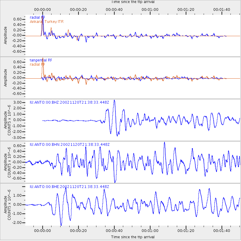
Signal To Noise
| Channel | StoN | STA | LTA |
| IU:ANTO:00:BHN:20021120T21:38:33.448Z | 0.8746912 | 4.7640086E-8 | 5.4465037E-8 |
| IU:ANTO:00:BHE:20021120T21:38:33.448Z | 3.7609265 | 1.3422675E-7 | 3.5689812E-8 |
| IU:ANTO:00:BHZ:20021120T21:38:33.448Z | 3.3811069 | 1.816333E-7 | 5.372007E-8 |
| Arrivals |
| Ps | 5.1 SECOND |
| PpPs | 15 SECOND |
| PsPs/PpSs | 20 SECOND |


