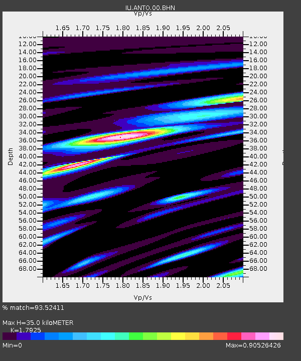
ANTO Ankara, Turkey - Earthquake Result Viewer
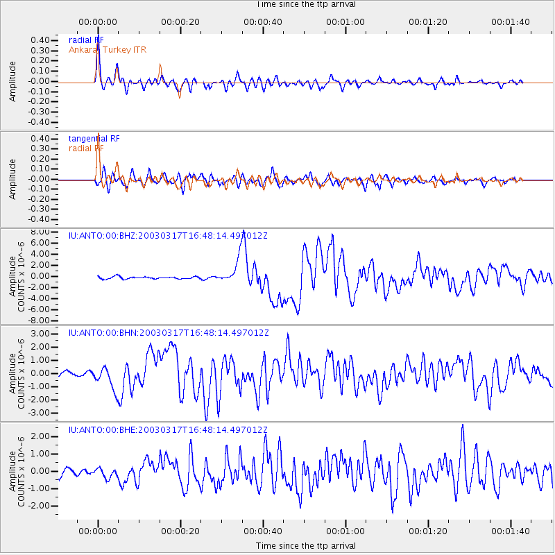
Earthquake location: Rat Islands, Aleutian Islands
Earthquake latitude/longitude: 51.3/178.0
Earthquake time(UTC): 2003/03/17 (076) 16:36:17 GMT
Earthquake Depth: 33 km
Earthquake Magnitude: 5.9 MB, 6.7 MS, 7.0 MW, 7.0 MW
Earthquake Catalog/Contributor: WHDF/NEIC
Network: IU Global Seismograph Network (GSN - IRIS/USGS)
Station: ANTO Ankara, Turkey
Lat/Lon: 39.87 N/32.79 E
Elevation: 883 m
Distance: 84.3 deg
Az: 333.793 deg
Baz: 21.128 deg
Ray Param: 0.045561153
Estimated Moho Depth: 35.0 km
Estimated Crust Vp/Vs: 1.79
Assumed Crust Vp: 6.159 km/s
Estimated Crust Vs: 3.436 km/s
Estimated Crust Poisson's Ratio: 0.27
Radial Match: 93.52411 %
Radial Bump: 400
Transverse Match: 85.935486 %
Transverse Bump: 400
SOD ConfigId: 4714
Insert Time: 2010-03-03 13:59:24.813 +0000
GWidth: 2.5
Max Bumps: 400
Tol: 0.001

Signal To Noise

ChannelStoNSTALTA
IU:ANTO:00:BHN:20030317T16:48:14.497012Z3.87664328.8839965E-72.2916724E-7
IU:ANTO:00:BHE:20030317T16:48:14.497012Z1.16283512.7594882E-72.373069E-7
IU:ANTO:00:BHZ:20030317T16:48:14.497012Z11.6230192.3513649E-62.0230242E-7
Arrivals
Ps4.6 SECOND
PpPs16 SECOND
PsPs/PpSs20 SECOND