You are here: Home > Network List > UW - Pacific Northwest Regional Seismic Network Stations List
> Station MRBL Marblemount, WA, USA > Earthquake Result Viewer
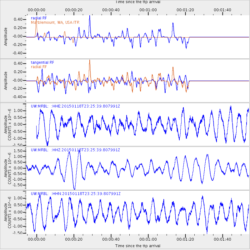
MRBL Marblemount, WA, USA - Earthquake Result Viewer
*The percent match for this event was below the threshold and hence no stack was calculated.
| Earthquake location: |
Southern East Pacific Rise |
| Earthquake latitude/longitude: |
-35.5/-105.8 |
| Earthquake time(UTC): |
2015/01/18 (018) 23:13:36 GMT |
| Earthquake Depth: |
8.3 km |
| Earthquake Magnitude: |
5.7 MWW, 5.5 MWB, 5.7 MWC |
| Earthquake Catalog/Contributor: |
NEIC PDE/NEIC COMCAT |
|
| Network: |
UW Pacific Northwest Regional Seismic Network |
| Station: |
MRBL Marblemount, WA, USA |
| Lat/Lon: |
48.52 N/121.48 W |
| Elevation: |
75 m |
|
| Distance: |
84.8 deg |
| Az: |
349.573 deg |
| Baz: |
167.161 deg |
| Ray Param: |
$rayparam |
*The percent match for this event was below the threshold and hence was not used in the summary stack. |
|
| Radial Match: |
50.69961 % |
| Radial Bump: |
387 |
| Transverse Match: |
51.60812 % |
| Transverse Bump: |
400 |
| SOD ConfigId: |
837871 |
| Insert Time: |
2015-02-03 03:23:50.738 +0000 |
| GWidth: |
2.5 |
| Max Bumps: |
400 |
| Tol: |
0.001 |
|
Signal To Noise
| Channel | StoN | STA | LTA |
| UW:MRBL: :HHZ:20150118T23:25:39.807991Z | 0.47224513 | 2.376568E-7 | 5.032488E-7 |
| UW:MRBL: :HHN:20150118T23:25:39.807991Z | 2.424205 | 8.855671E-7 | 3.6530204E-7 |
| UW:MRBL: :HHE:20150118T23:25:39.807991Z | 0.54773074 | 3.582965E-7 | 6.5414713E-7 |
| Arrivals |
| Ps | |
| PpPs | |
| PsPs/PpSs | |


