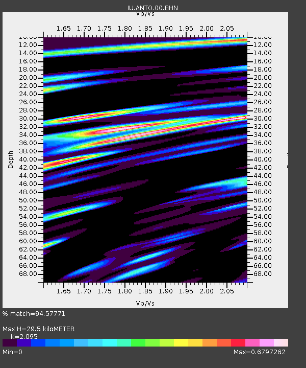
ANTO Ankara, Turkey - Earthquake Result Viewer

Earthquake location: Near S. Coast Of Honshu, Japan
Earthquake latitude/longitude: 33.1/137.2
Earthquake time(UTC): 2004/09/08 (252) 14:58:25 GMT
Earthquake Depth: 21 km
Earthquake Magnitude: 6.2 MB, 5.8 MS, 6.2 MW, 6.1 MW
Earthquake Catalog/Contributor: WHDF/NEIC
Network: IU Global Seismograph Network (GSN - IRIS/USGS)
Station: ANTO Ankara, Turkey
Lat/Lon: 39.87 N/32.79 E
Elevation: 883 m
Distance: 79.2 deg
Az: 310.644 deg
Baz: 55.81 deg
Ray Param: 0.049078148
Estimated Moho Depth: 29.5 km
Estimated Crust Vp/Vs: 2.10
Assumed Crust Vp: 6.159 km/s
Estimated Crust Vs: 2.94 km/s
Estimated Crust Poisson's Ratio: 0.35
Radial Match: 94.57771 %
Radial Bump: 400
Transverse Match: 86.25511 %
Transverse Bump: 400
SOD ConfigId: 2459
Insert Time: 2010-03-03 13:59:56.158 +0000
GWidth: 2.5
Max Bumps: 400
Tol: 0.001

Signal To Noise

ChannelStoNSTALTA
IU:ANTO:00:BHN:20040908T15:09:58.059004Z11.0961156.2595086E-75.641171E-8
IU:ANTO:00:BHE:20040908T15:09:58.059004Z10.8000176.8056414E-76.30151E-8
IU:ANTO:00:BHZ:20040908T15:09:58.059004Z36.6975862.498826E-66.809238E-8
Arrivals
Ps5.4 SECOND
PpPs14 SECOND
PsPs/PpSs20 SECOND