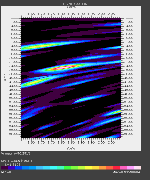
ANTO Ankara, Turkey - Earthquake Result Viewer

Earthquake location: South Of Aleutian Islands
Earthquake latitude/longitude: 51.8/-166.3
Earthquake time(UTC): 2004/08/07 (220) 09:30:16 GMT
Earthquake Depth: 8.0 km
Earthquake Magnitude: 6.3 MB, 5.4 MS, 6.0 MW, 6.0 MW
Earthquake Catalog/Contributor: WHDF/NEIC
Network: IU Global Seismograph Network (GSN - IRIS/USGS)
Station: ANTO Ankara, Turkey
Lat/Lon: 39.87 N/32.79 E
Elevation: 883 m
Distance: 87.2 deg
Az: 345.392 deg
Baz: 11.754 deg
Ray Param: 0.043466214
Estimated Moho Depth: 34.5 km
Estimated Crust Vp/Vs: 1.81
Assumed Crust Vp: 6.159 km/s
Estimated Crust Vs: 3.398 km/s
Estimated Crust Poisson's Ratio: 0.28
Radial Match: 90.2915 %
Radial Bump: 400
Transverse Match: 87.56316 %
Transverse Bump: 400
SOD ConfigId: 2459
Insert Time: 2010-03-03 14:00:02.831 +0000
GWidth: 2.5
Max Bumps: 400
Tol: 0.001

Signal To Noise

ChannelStoNSTALTA
IU:ANTO:00:BHN:20040807T09:42:32.309995Z9.3969352.9853965E-73.1769893E-8
IU:ANTO:00:BHE:20040807T09:42:32.309995Z1.54380696.3089935E-84.0866468E-8
IU:ANTO:00:BHZ:20040807T09:42:32.309995Z11.2069358.6375684E-77.707342E-8
Arrivals
Ps4.6 SECOND
PpPs15 SECOND
PsPs/PpSs20 SECOND