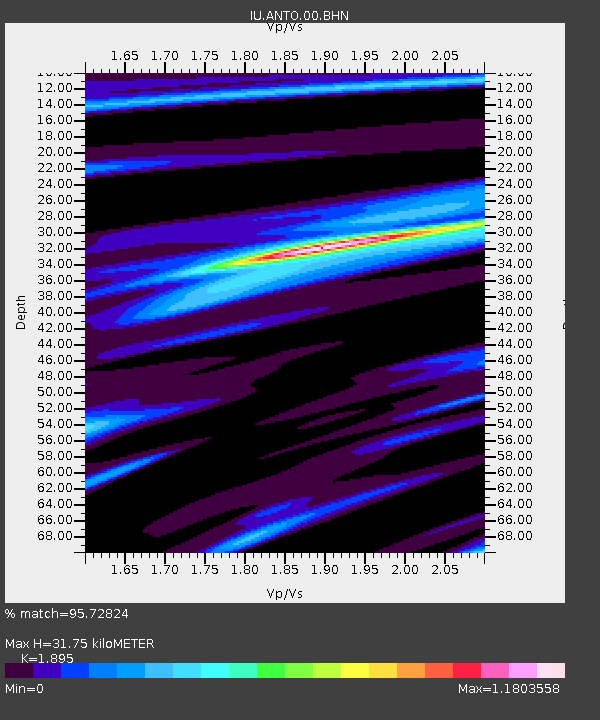
ANTO Ankara, Turkey - Earthquake Result Viewer
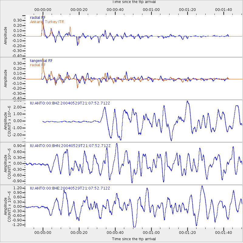
Earthquake location: Off East Coast Of Honshu, Japan
Earthquake latitude/longitude: 34.3/141.4
Earthquake time(UTC): 2004/05/29 (150) 20:56:09 GMT
Earthquake Depth: 16 km
Earthquake Magnitude: 5.6 MB, 6.6 MS, 6.5 MW, 6.3 MW
Earthquake Catalog/Contributor: WHDF/NEIC
Network: IU Global Seismograph Network (GSN - IRIS/USGS)
Station: ANTO Ankara, Turkey
Lat/Lon: 39.87 N/32.79 E
Elevation: 883 m
Distance: 81.1 deg
Az: 312.421 deg
Baz: 52.61 deg
Ray Param: 0.047793955
Estimated Moho Depth: 31.75 km
Estimated Crust Vp/Vs: 1.89
Assumed Crust Vp: 6.159 km/s
Estimated Crust Vs: 3.25 km/s
Estimated Crust Poisson's Ratio: 0.31
Radial Match: 95.72824 %
Radial Bump: 309
Transverse Match: 83.65769 %
Transverse Bump: 400
SOD ConfigId: 2459
Insert Time: 2010-03-03 14:00:13.956 +0000
GWidth: 2.5
Max Bumps: 400
Tol: 0.001

Signal To Noise

ChannelStoNSTALTA
IU:ANTO:00:BHN:20040529T21:07:52.712Z5.1711011.840921E-73.5600177E-8
IU:ANTO:00:BHE:20040529T21:07:52.712Z6.8892462.581788E-73.7475626E-8
IU:ANTO:00:BHZ:20040529T21:07:52.712Z21.195339.801321E-74.6242835E-8
Arrivals
Ps4.7 SECOND
PpPs15 SECOND
PsPs/PpSs19 SECOND