You are here: Home > Network List > UW - Pacific Northwest Regional Seismic Network Stations List
> Station UMAT Pilot Rock, OR, USA > Earthquake Result Viewer
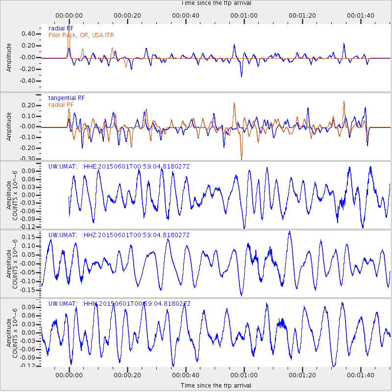
UMAT Pilot Rock, OR, USA - Earthquake Result Viewer
*The percent match for this event was below the threshold and hence no stack was calculated.
| Earthquake location: |
Kuril Islands |
| Earthquake latitude/longitude: |
44.1/146.9 |
| Earthquake time(UTC): |
2015/06/01 (152) 00:49:17 GMT |
| Earthquake Depth: |
85 km |
| Earthquake Magnitude: |
4.2 mb |
| Earthquake Catalog/Contributor: |
ISC/ISC |
|
| Network: |
UW Pacific Northwest Regional Seismic Network |
| Station: |
UMAT Pilot Rock, OR, USA |
| Lat/Lon: |
45.29 N/118.96 W |
| Elevation: |
1318 m |
|
| Distance: |
63.0 deg |
| Az: |
52.223 deg |
| Baz: |
306.167 deg |
| Ray Param: |
$rayparam |
*The percent match for this event was below the threshold and hence was not used in the summary stack. |
|
| Radial Match: |
59.11794 % |
| Radial Bump: |
361 |
| Transverse Match: |
40.60011 % |
| Transverse Bump: |
400 |
| SOD ConfigId: |
7422571 |
| Insert Time: |
2019-04-19 04:21:02.187 +0000 |
| GWidth: |
2.5 |
| Max Bumps: |
400 |
| Tol: |
0.001 |
|
Signal To Noise
| Channel | StoN | STA | LTA |
| UW:UMAT: :HHZ:20150601T00:59:04.818027Z | 0.9753984 | 7.78767E-8 | 7.984091E-8 |
| UW:UMAT: :HHN:20150601T00:59:04.818027Z | 1.0969986 | 5.955383E-8 | 5.4287973E-8 |
| UW:UMAT: :HHE:20150601T00:59:04.818027Z | 1.3462723 | 6.055775E-8 | 4.4981796E-8 |
| Arrivals |
| Ps | |
| PpPs | |
| PsPs/PpSs | |


