You are here: Home > Network List > CI - Caltech Regional Seismic Network Stations List
> Station OSI Osito Audit > Earthquake Result Viewer
OSI Osito Audit - Earthquake Result Viewer
| Earthquake location: |
Kodiak Island Region, Alaska |
| Earthquake latitude/longitude: |
57.4/-154.5 |
| Earthquake time(UTC): |
1999/12/06 (340) 23:12:33 GMT |
| Earthquake Depth: |
66 km |
| Earthquake Magnitude: |
6.8 MB, 7.0 MW, 7.0 ML |
| Earthquake Catalog/Contributor: |
WHDF/NEIC |
|
| Network: |
CI Caltech Regional Seismic Network |
| Station: |
OSI Osito Audit |
| Lat/Lon: |
34.61 N/118.72 W |
| Elevation: |
718 m |
|
| Distance: |
33.1 deg |
| Az: |
118.043 deg |
| Baz: |
324.613 deg |
| Ray Param: |
0.07819662 |
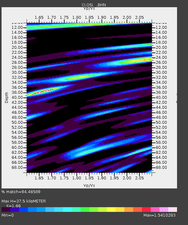
| Estimated Moho Depth: |
37.5 km |
| Estimated Crust Vp/Vs: |
1.66 |
| Assumed Crust Vp: |
6.1 km/s |
| Estimated Crust Vs: |
3.675 km/s |
| Estimated Crust Poisson's Ratio: |
0.22 |
|
| Radial Match: |
94.46589 % |
| Radial Bump: |
400 |
| Transverse Match: |
80.06988 % |
| Transverse Bump: |
400 |
| SOD ConfigId: |
3787 |
| Insert Time: |
2010-02-25 21:28:51.414 +0000 |
| GWidth: |
2.5 |
| Max Bumps: |
400 |
| Tol: |
0.001 |
|
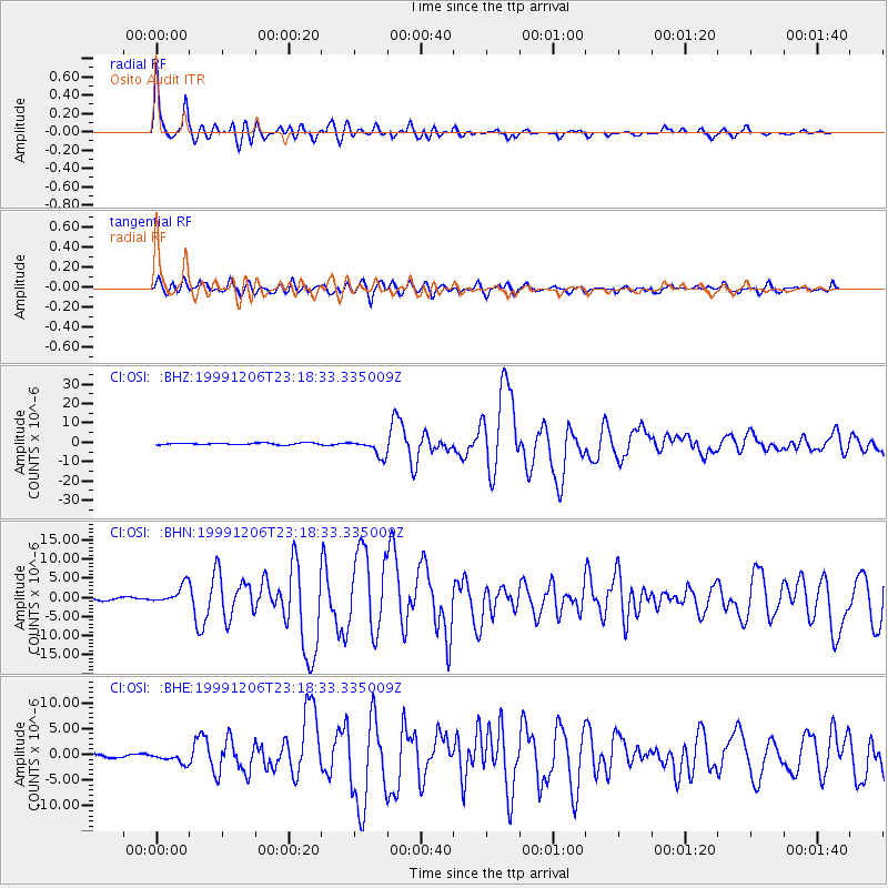
Signal To Noise
| Channel | StoN | STA | LTA |
| CI:OSI: :BHN:19991206T23:18:33.335009Z | 9.408959 | 2.4847154E-6 | 2.6407972E-7 |
| CI:OSI: :BHE:19991206T23:18:33.335009Z | 3.6808877 | 1.0239593E-6 | 2.7818268E-7 |
| CI:OSI: :BHZ:19991206T23:18:33.335009Z | 10.201882 | 4.4034405E-6 | 4.3163016E-7 |
| Arrivals |
| Ps | 4.4 SECOND |
| PpPs | 15 SECOND |
| PsPs/PpSs | 20 SECOND |


