You are here: Home > Network List > IU - Global Seismograph Network (GSN - IRIS/USGS) Stations List
> Station ANTO Ankara, Turkey > Earthquake Result Viewer
ANTO Ankara, Turkey - Earthquake Result Viewer
| Earthquake location: |
Xizang |
| Earthquake latitude/longitude: |
30.7/83.7 |
| Earthquake time(UTC): |
2004/07/11 (193) 23:08:44 GMT |
| Earthquake Depth: |
13 km |
| Earthquake Magnitude: |
5.7 MB, 6.2 MS, 6.2 MW, 6.2 MW |
| Earthquake Catalog/Contributor: |
WHDF/NEIC |
|
| Network: |
IU Global Seismograph Network (GSN - IRIS/USGS) |
| Station: |
ANTO Ankara, Turkey |
| Lat/Lon: |
39.87 N/32.79 E |
| Elevation: |
883 m |
|
| Distance: |
42.0 deg |
| Az: |
296.933 deg |
| Baz: |
86.244 deg |
| Ray Param: |
0.073396884 |
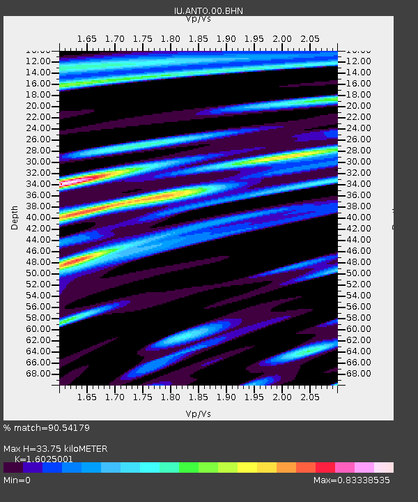
| Estimated Moho Depth: |
33.75 km |
| Estimated Crust Vp/Vs: |
1.60 |
| Assumed Crust Vp: |
6.159 km/s |
| Estimated Crust Vs: |
3.843 km/s |
| Estimated Crust Poisson's Ratio: |
0.18 |
|
| Radial Match: |
90.54179 % |
| Radial Bump: |
400 |
| Transverse Match: |
78.758896 % |
| Transverse Bump: |
400 |
| SOD ConfigId: |
2459 |
| Insert Time: |
2010-03-03 14:00:36.185 +0000 |
| GWidth: |
2.5 |
| Max Bumps: |
400 |
| Tol: |
0.001 |
|
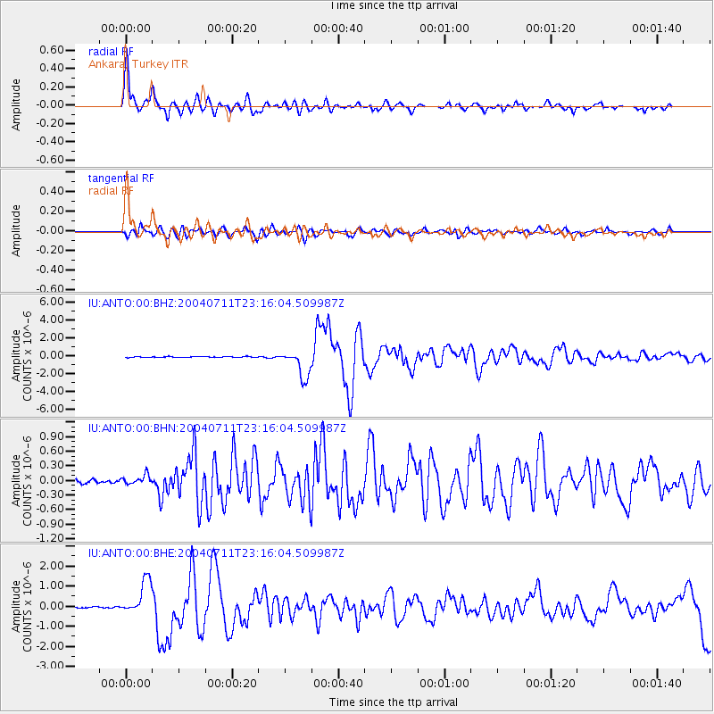
Signal To Noise
| Channel | StoN | STA | LTA |
| IU:ANTO:00:BHN:20040711T23:16:04.509987Z | 2.910976 | 9.769414E-8 | 3.3560614E-8 |
| IU:ANTO:00:BHE:20040711T23:16:04.509987Z | 17.294865 | 8.7243876E-7 | 5.0444964E-8 |
| IU:ANTO:00:BHZ:20040711T23:16:04.509987Z | 33.407146 | 1.5621749E-6 | 4.6761702E-8 |
| Arrivals |
| Ps | 3.5 SECOND |
| PpPs | 13 SECOND |
| PsPs/PpSs | 17 SECOND |


