You are here: Home > Network List > IU - Global Seismograph Network (GSN - IRIS/USGS) Stations List
> Station ANTO Ankara, Turkey > Earthquake Result Viewer
ANTO Ankara, Turkey - Earthquake Result Viewer
| Earthquake location: |
Myanmar |
| Earthquake latitude/longitude: |
24.7/95.2 |
| Earthquake time(UTC): |
1994/08/08 (220) 21:08:31 GMT |
| Earthquake Depth: |
127 km |
| Earthquake Magnitude: |
6.0 MB, 5.1 UNKNOWN, 6.1 MW |
| Earthquake Catalog/Contributor: |
WHDF/NEIC |
|
| Network: |
IU Global Seismograph Network (GSN - IRIS/USGS) |
| Station: |
ANTO Ankara, Turkey |
| Lat/Lon: |
39.87 N/32.79 E |
| Elevation: |
883 m |
|
| Distance: |
53.9 deg |
| Az: |
302.376 deg |
| Baz: |
86.362 deg |
| Ray Param: |
0.06540322 |
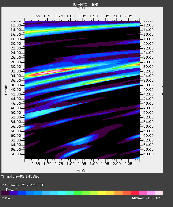
| Estimated Moho Depth: |
32.25 km |
| Estimated Crust Vp/Vs: |
1.70 |
| Assumed Crust Vp: |
6.159 km/s |
| Estimated Crust Vs: |
3.623 km/s |
| Estimated Crust Poisson's Ratio: |
0.24 |
|
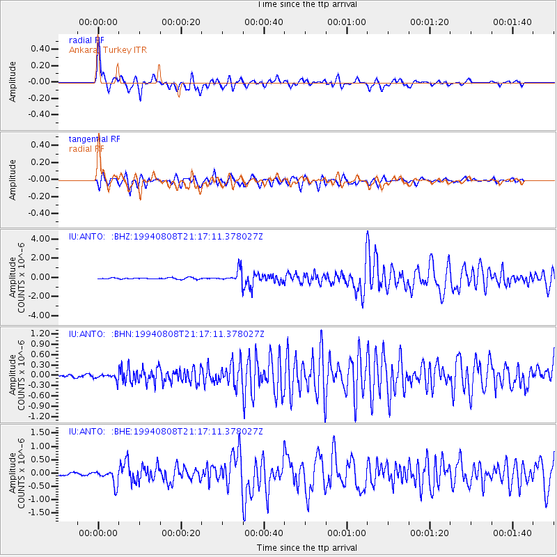
| Radial Match: |
92.145386 % |
| Radial Bump: |
400 |
| Transverse Match: |
85.15757 % |
| Transverse Bump: |
400 |
| SOD ConfigId: |
16938 |
| Insert Time: |
2010-03-03 14:01:06.245 +0000 |
| GWidth: |
2.5 |
| Max Bumps: |
400 |
| Tol: |
0.001 |
|
Signal To Noise
| Channel | StoN | STA | LTA |
| IU:ANTO: :BHN:19940808T21:17:11.378027Z | 2.953993 | 8.995292E-8 | 3.0451297E-8 |
| IU:ANTO: :BHE:19940808T21:17:11.378027Z | 7.5993924 | 2.8676084E-7 | 3.7734708E-8 |
| IU:ANTO: :BHZ:19940808T21:17:11.378027Z | 9.621336 | 6.932267E-7 | 7.205098E-8 |
| Arrivals |
| Ps | 3.9 SECOND |
| PpPs | 13 SECOND |
| PsPs/PpSs | 17 SECOND |


