You are here: Home > Network List > N4 - Central and EAstern US Network Stations List
> Station U56A King, NC, USA > Earthquake Result Viewer
U56A King, NC, USA - Earthquake Result Viewer
| Earthquake location: |
Off Coast Of Oregon |
| Earthquake latitude/longitude: |
44.4/-129.8 |
| Earthquake time(UTC): |
2015/06/01 (152) 06:52:41 GMT |
| Earthquake Depth: |
10 km |
| Earthquake Magnitude: |
5.8 MWP, 5.8 MI |
| Earthquake Catalog/Contributor: |
NEIC PDE/NEIC COMCAT |
|
| Network: |
N4 Central and EAstern US Network |
| Station: |
U56A King, NC, USA |
| Lat/Lon: |
36.35 N/80.38 W |
| Elevation: |
363 m |
|
| Distance: |
38.0 deg |
| Az: |
84.774 deg |
| Baz: |
297.913 deg |
| Ray Param: |
0.07582596 |
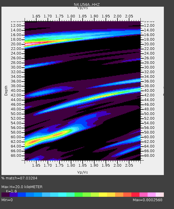
| Estimated Moho Depth: |
20.0 km |
| Estimated Crust Vp/Vs: |
1.60 |
| Assumed Crust Vp: |
6.159 km/s |
| Estimated Crust Vs: |
3.849 km/s |
| Estimated Crust Poisson's Ratio: |
0.18 |
|
| Radial Match: |
87.03284 % |
| Radial Bump: |
398 |
| Transverse Match: |
48.162098 % |
| Transverse Bump: |
400 |
| SOD ConfigId: |
7422571 |
| Insert Time: |
2019-04-19 04:25:28.688 +0000 |
| GWidth: |
2.5 |
| Max Bumps: |
400 |
| Tol: |
0.001 |
|

Signal To Noise
| Channel | StoN | STA | LTA |
| N4:U56A: :HHZ:20150601T06:59:27.900Z | 2.106826 | 2.6971387E-7 | 1.2801905E-7 |
| N4:U56A: :HHN:20150601T06:59:27.900Z | 0.6601278 | 7.417341E-8 | 1.12362194E-7 |
| N4:U56A: :HHE:20150601T06:59:27.900Z | 1.520391 | 1.5530742E-7 | 1.02149656E-7 |
| Arrivals |
| Ps | 2.1 SECOND |
| PpPs | 7.8 SECOND |
| PsPs/PpSs | 9.9 SECOND |


