You are here: Home > Network List > N4 - Central and EAstern US Network Stations List
> Station Z51A Franklin, GA, USA > Earthquake Result Viewer
Z51A Franklin, GA, USA - Earthquake Result Viewer
| Earthquake location: |
Off Coast Of Oregon |
| Earthquake latitude/longitude: |
44.4/-129.8 |
| Earthquake time(UTC): |
2015/06/01 (152) 06:52:41 GMT |
| Earthquake Depth: |
10 km |
| Earthquake Magnitude: |
5.8 MWP, 5.8 MI |
| Earthquake Catalog/Contributor: |
NEIC PDE/NEIC COMCAT |
|
| Network: |
N4 Central and EAstern US Network |
| Station: |
Z51A Franklin, GA, USA |
| Lat/Lon: |
33.32 N/85.17 W |
| Elevation: |
249 m |
|
| Distance: |
36.0 deg |
| Az: |
92.375 deg |
| Baz: |
301.26 deg |
| Ray Param: |
0.07689673 |
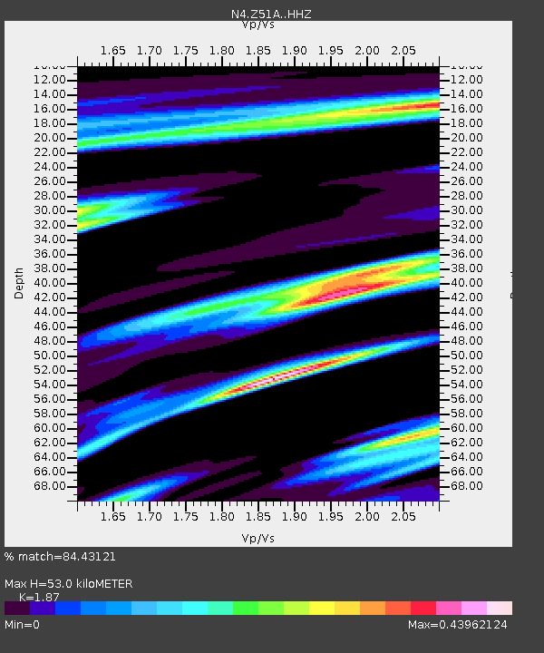
| Estimated Moho Depth: |
53.0 km |
| Estimated Crust Vp/Vs: |
1.87 |
| Assumed Crust Vp: |
6.719 km/s |
| Estimated Crust Vs: |
3.593 km/s |
| Estimated Crust Poisson's Ratio: |
0.30 |
|
| Radial Match: |
84.43121 % |
| Radial Bump: |
303 |
| Transverse Match: |
54.262882 % |
| Transverse Bump: |
400 |
| SOD ConfigId: |
7422571 |
| Insert Time: |
2019-04-19 04:25:44.051 +0000 |
| GWidth: |
2.5 |
| Max Bumps: |
400 |
| Tol: |
0.001 |
|

Signal To Noise
| Channel | StoN | STA | LTA |
| N4:Z51A: :HHZ:20150601T06:59:11.280005Z | 3.3682683 | 3.567507E-7 | 1.0591517E-7 |
| N4:Z51A: :HHN:20150601T06:59:11.280005Z | 1.585435 | 1.5251817E-7 | 9.619957E-8 |
| N4:Z51A: :HHE:20150601T06:59:11.280005Z | 2.3747327 | 2.0719868E-7 | 8.7251365E-8 |
| Arrivals |
| Ps | 7.4 SECOND |
| PpPs | 21 SECOND |
| PsPs/PpSs | 28 SECOND |


