You are here: Home > Network List > IU - Global Seismograph Network (GSN - IRIS/USGS) Stations List
> Station ANTO Ankara, Turkey > Earthquake Result Viewer
ANTO Ankara, Turkey - Earthquake Result Viewer
| Earthquake location: |
Ryukyu Islands, Japan |
| Earthquake latitude/longitude: |
29.3/129.9 |
| Earthquake time(UTC): |
1994/09/13 (256) 04:28:01 GMT |
| Earthquake Depth: |
37 km |
| Earthquake Magnitude: |
5.8 MB, 6.3 MS, 6.2 UNKNOWN, 6.1 MW |
| Earthquake Catalog/Contributor: |
WHDF/NEIC |
|
| Network: |
IU Global Seismograph Network (GSN - IRIS/USGS) |
| Station: |
ANTO Ankara, Turkey |
| Lat/Lon: |
39.87 N/32.79 E |
| Elevation: |
883 m |
|
| Distance: |
76.8 deg |
| Az: |
308.334 deg |
| Baz: |
62.944 deg |
| Ray Param: |
0.050673634 |
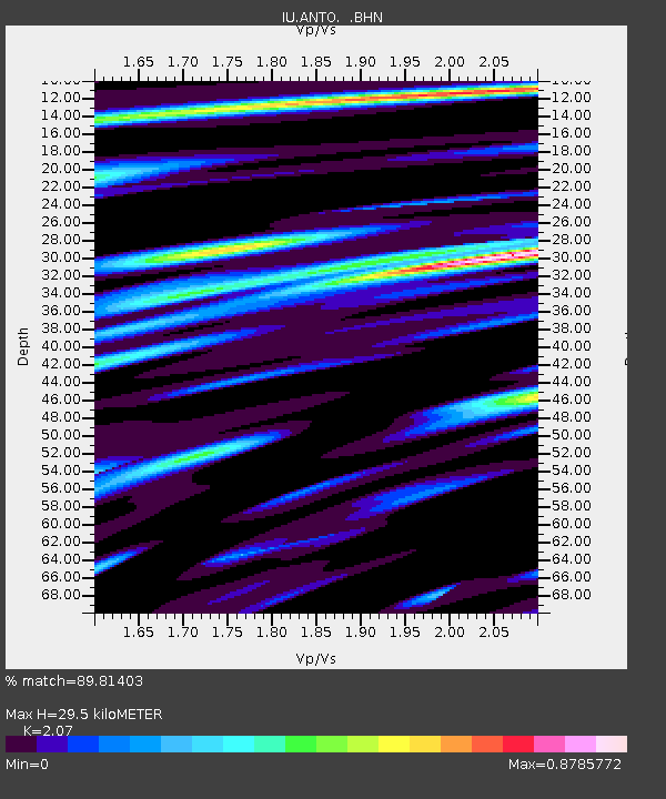
| Estimated Moho Depth: |
29.5 km |
| Estimated Crust Vp/Vs: |
2.07 |
| Assumed Crust Vp: |
6.159 km/s |
| Estimated Crust Vs: |
2.975 km/s |
| Estimated Crust Poisson's Ratio: |
0.35 |
|
| Radial Match: |
89.81403 % |
| Radial Bump: |
400 |
| Transverse Match: |
83.35234 % |
| Transverse Bump: |
400 |
| SOD ConfigId: |
17000 |
| Insert Time: |
2010-03-03 14:01:50.506 +0000 |
| GWidth: |
2.5 |
| Max Bumps: |
400 |
| Tol: |
0.001 |
|
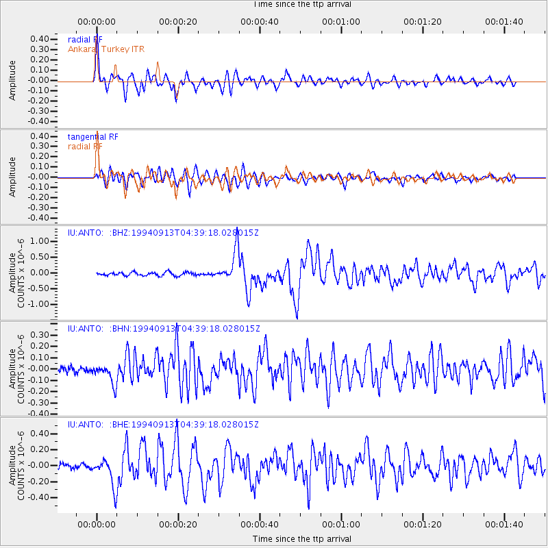
Signal To Noise
| Channel | StoN | STA | LTA |
| IU:ANTO: :BHN:19940913T04:39:18.028015Z | 2.414059 | 9.056217E-8 | 3.7514482E-8 |
| IU:ANTO: :BHE:19940913T04:39:18.028015Z | 5.2102156 | 1.8255518E-7 | 3.503793E-8 |
| IU:ANTO: :BHZ:19940913T04:39:18.028015Z | 9.917038 | 5.31643E-7 | 5.3609053E-8 |
| Arrivals |
| Ps | 5.3 SECOND |
| PpPs | 14 SECOND |
| PsPs/PpSs | 20 SECOND |


