You are here: Home > Network List > TA - USArray Transportable Network (new EarthScope stations) Stations List
> Station O48A Farmland, IN, USA > Earthquake Result Viewer
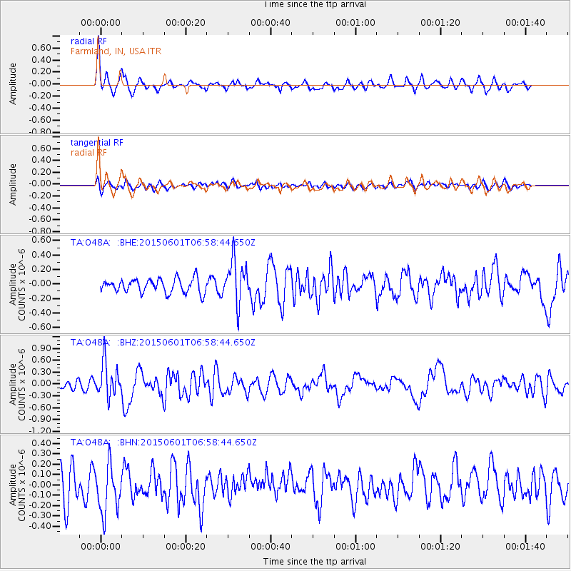
O48A Farmland, IN, USA - Earthquake Result Viewer
*The percent match for this event was below the threshold and hence no stack was calculated.
| Earthquake location: |
Off Coast Of Oregon |
| Earthquake latitude/longitude: |
44.4/-129.8 |
| Earthquake time(UTC): |
2015/06/01 (152) 06:52:41 GMT |
| Earthquake Depth: |
10 km |
| Earthquake Magnitude: |
5.8 MWP, 5.8 MI |
| Earthquake Catalog/Contributor: |
NEIC PDE/NEIC COMCAT |
|
| Network: |
TA USArray Transportable Network (new EarthScope stations) |
| Station: |
O48A Farmland, IN, USA |
| Lat/Lon: |
40.26 N/85.16 W |
| Elevation: |
300 m |
|
| Distance: |
32.9 deg |
| Az: |
81.427 deg |
| Baz: |
292.235 deg |
| Ray Param: |
$rayparam |
*The percent match for this event was below the threshold and hence was not used in the summary stack. |
|
| Radial Match: |
74.66619 % |
| Radial Bump: |
400 |
| Transverse Match: |
49.931053 % |
| Transverse Bump: |
400 |
| SOD ConfigId: |
7422571 |
| Insert Time: |
2019-04-19 04:27:05.525 +0000 |
| GWidth: |
2.5 |
| Max Bumps: |
400 |
| Tol: |
0.001 |
|
Signal To Noise
| Channel | StoN | STA | LTA |
| TA:O48A: :BHZ:20150601T06:58:44.650Z | 3.866761 | 4.498575E-7 | 1.1633962E-7 |
| TA:O48A: :BHN:20150601T06:58:44.650Z | 1.3677081 | 2.3631694E-7 | 1.7278316E-7 |
| TA:O48A: :BHE:20150601T06:58:44.650Z | 3.168281 | 3.0252895E-7 | 9.548677E-8 |
| Arrivals |
| Ps | |
| PpPs | |
| PsPs/PpSs | |


