You are here: Home > Network List > IU - Global Seismograph Network (GSN - IRIS/USGS) Stations List
> Station ANTO Ankara, Turkey > Earthquake Result Viewer
ANTO Ankara, Turkey - Earthquake Result Viewer
| Earthquake location: |
Kuril Islands |
| Earthquake latitude/longitude: |
43.7/147.3 |
| Earthquake time(UTC): |
1994/10/04 (277) 13:22:58 GMT |
| Earthquake Depth: |
33 km |
| Earthquake Magnitude: |
7.4 MB, 8.1 MS, 8.3 UNKNOWN, 8.2 MW |
| Earthquake Catalog/Contributor: |
WHDF/NEIC |
|
| Network: |
IU Global Seismograph Network (GSN - IRIS/USGS) |
| Station: |
ANTO Ankara, Turkey |
| Lat/Lon: |
39.87 N/32.79 E |
| Elevation: |
883 m |
|
| Distance: |
78.0 deg |
| Az: |
314.294 deg |
| Baz: |
42.412 deg |
| Ray Param: |
0.049891673 |
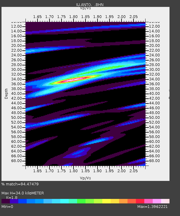
| Estimated Moho Depth: |
34.0 km |
| Estimated Crust Vp/Vs: |
1.80 |
| Assumed Crust Vp: |
6.159 km/s |
| Estimated Crust Vs: |
3.421 km/s |
| Estimated Crust Poisson's Ratio: |
0.28 |
|
| Radial Match: |
94.47479 % |
| Radial Bump: |
400 |
| Transverse Match: |
85.7107 % |
| Transverse Bump: |
400 |
| SOD ConfigId: |
17000 |
| Insert Time: |
2010-03-03 14:01:57.870 +0000 |
| GWidth: |
2.5 |
| Max Bumps: |
400 |
| Tol: |
0.001 |
|
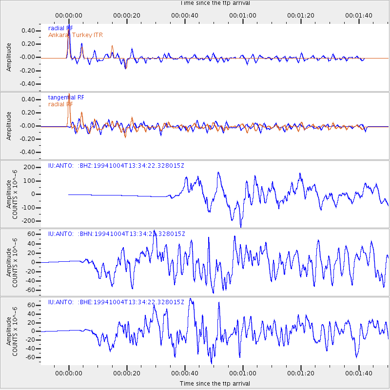
Signal To Noise
| Channel | StoN | STA | LTA |
| IU:ANTO: :BHN:19941004T13:34:22.328015Z | 4.5514526 | 3.6076538E-6 | 7.926379E-7 |
| IU:ANTO: :BHE:19941004T13:34:22.328015Z | 5.062812 | 3.3406588E-6 | 6.598426E-7 |
| IU:ANTO: :BHZ:19941004T13:34:22.328015Z | 3.8099194 | 9.903029E-6 | 2.5992754E-6 |
| Arrivals |
| Ps | 4.5 SECOND |
| PpPs | 15 SECOND |
| PsPs/PpSs | 20 SECOND |


