You are here: Home > Network List > IU - Global Seismograph Network (GSN - IRIS/USGS) Stations List
> Station ANTO Ankara, Turkey > Earthquake Result Viewer
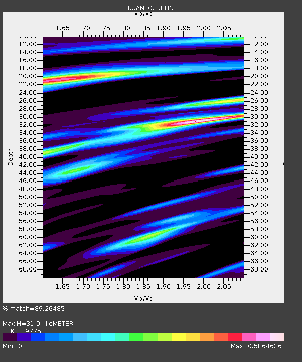
ANTO Ankara, Turkey - Earthquake Result Viewer
| Earthquake location: |
Halmahera, Indonesia |
| Earthquake latitude/longitude: |
-1.4/127.5 |
| Earthquake time(UTC): |
1995/02/13 (044) 15:04:26 GMT |
| Earthquake Depth: |
33 km |
| Earthquake Magnitude: |
6.2 MB, 6.8 MS, 6.8 UNKNOWN, 6.7 MW |
| Earthquake Catalog/Contributor: |
WHDF/NEIC |
|
| Network: |
IU Global Seismograph Network (GSN - IRIS/USGS) |
| Station: |
ANTO Ankara, Turkey |
| Lat/Lon: |
39.87 N/32.79 E |
| Elevation: |
883 m |
|
| Distance: |
94.5 deg |
| Az: |
309.702 deg |
| Baz: |
88.011 deg |
| Ray Param: |
0.04101725 |
| Estimated Moho Depth: |
31.0 km |
| Estimated Crust Vp/Vs: |
1.98 |
| Assumed Crust Vp: |
6.159 km/s |
| Estimated Crust Vs: |
3.114 km/s |
| Estimated Crust Poisson's Ratio: |
0.33 |
|
| Radial Match: |
89.26485 % |
| Radial Bump: |
400 |
| Transverse Match: |
66.245766 % |
| Transverse Bump: |
400 |
| SOD ConfigId: |
6273 |
| Insert Time: |
2010-03-03 14:02:42.908 +0000 |
| GWidth: |
2.5 |
| Max Bumps: |
400 |
| Tol: |
0.001 |
|

Signal To Noise
| Channel | StoN | STA | LTA |
| IU:ANTO: :BHN:19950213T15:17:12.128015Z | 1.3027251 | 6.7855936E-8 | 5.2087685E-8 |
| IU:ANTO: :BHE:19950213T15:17:12.128015Z | 3.4239626 | 1.3548623E-7 | 3.957001E-8 |
| IU:ANTO: :BHZ:19950213T15:17:12.128015Z | 8.994695 | 6.0418614E-7 | 6.717139E-8 |
| Arrivals |
| Ps | 5.0 SECOND |
| PpPs | 15 SECOND |
| PsPs/PpSs | 20 SECOND |


