You are here: Home > Network List > IU - Global Seismograph Network (GSN - IRIS/USGS) Stations List
> Station ANTO Ankara, Turkey > Earthquake Result Viewer
ANTO Ankara, Turkey - Earthquake Result Viewer
| Earthquake location: |
Samar, Philippines |
| Earthquake latitude/longitude: |
12.1/125.9 |
| Earthquake time(UTC): |
1995/04/21 (111) 05:17:00 GMT |
| Earthquake Depth: |
23 km |
| Earthquake Magnitude: |
5.6 MB, 6.9 MS, 6.7 UNKNOWN, 6.7 MW |
| Earthquake Catalog/Contributor: |
WHDF/NEIC |
|
| Network: |
IU Global Seismograph Network (GSN - IRIS/USGS) |
| Station: |
ANTO Ankara, Turkey |
| Lat/Lon: |
39.87 N/32.79 E |
| Elevation: |
883 m |
|
| Distance: |
84.7 deg |
| Az: |
309.49 deg |
| Baz: |
78.695 deg |
| Ray Param: |
0.04525676 |
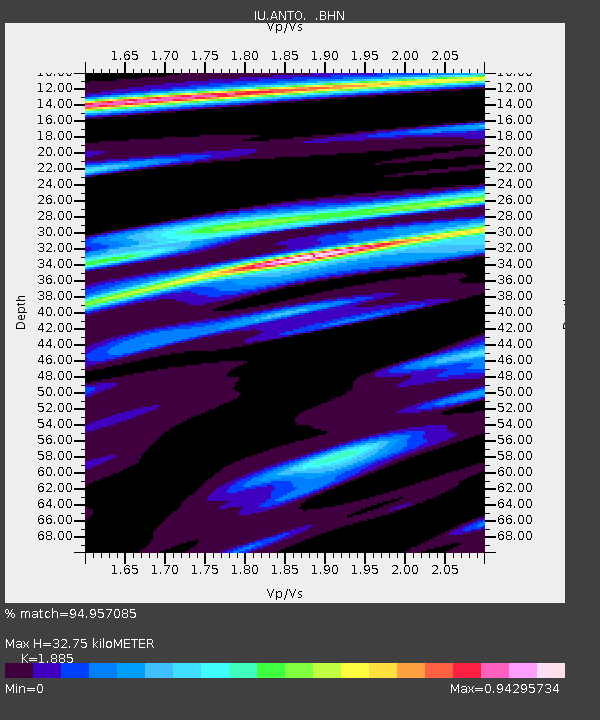
| Estimated Moho Depth: |
32.75 km |
| Estimated Crust Vp/Vs: |
1.88 |
| Assumed Crust Vp: |
6.159 km/s |
| Estimated Crust Vs: |
3.267 km/s |
| Estimated Crust Poisson's Ratio: |
0.30 |
|
| Radial Match: |
94.957085 % |
| Radial Bump: |
400 |
| Transverse Match: |
85.7937 % |
| Transverse Bump: |
400 |
| SOD ConfigId: |
6273 |
| Insert Time: |
2010-03-03 14:03:04.957 +0000 |
| GWidth: |
2.5 |
| Max Bumps: |
400 |
| Tol: |
0.001 |
|
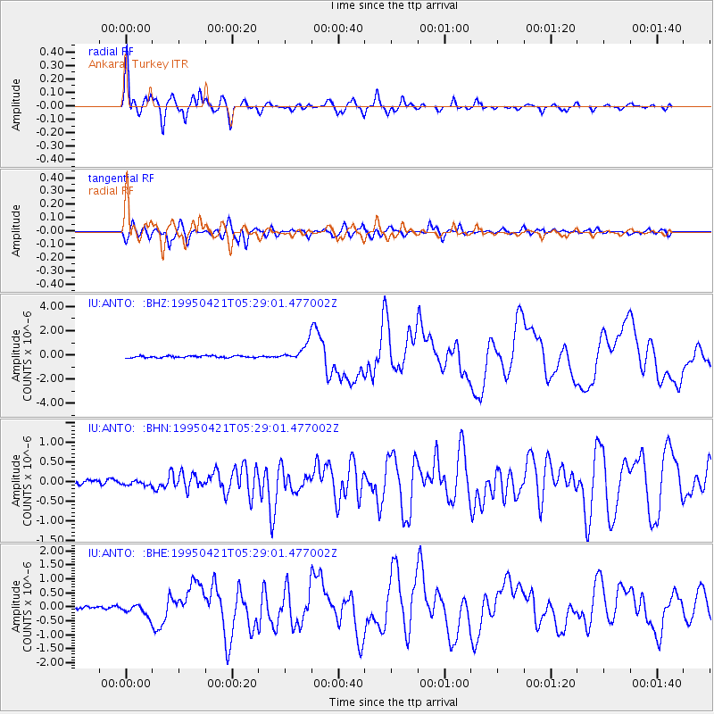
Signal To Noise
| Channel | StoN | STA | LTA |
| IU:ANTO: :BHN:19950421T05:29:01.477002Z | 1.2510731 | 6.2864174E-8 | 5.0248204E-8 |
| IU:ANTO: :BHE:19950421T05:29:01.477002Z | 4.6738267 | 2.2183882E-7 | 4.7464063E-8 |
| IU:ANTO: :BHZ:19950421T05:29:01.477002Z | 9.509771 | 7.186189E-7 | 7.556637E-8 |
| Arrivals |
| Ps | 4.8 SECOND |
| PpPs | 15 SECOND |
| PsPs/PpSs | 20 SECOND |


