ANTO Ankara, Turkey - Earthquake Result Viewer
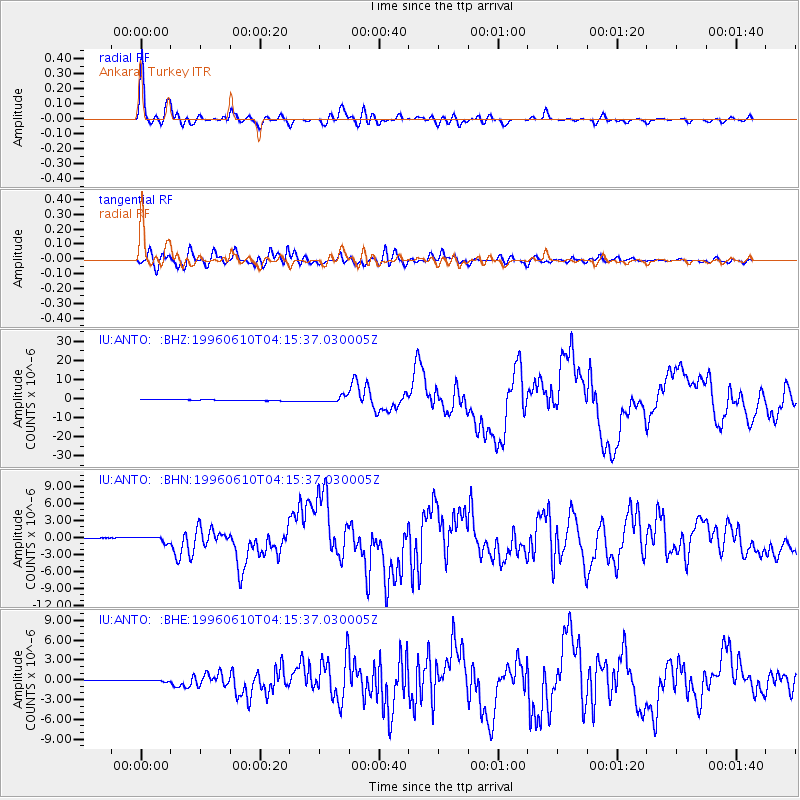
Earthquake location: Andreanof Islands, Aleutian Is.
Earthquake latitude/longitude: 51.6/-177.6
Earthquake time(UTC): 1996/06/10 (162) 04:03:35 GMT
Earthquake Depth: 33 km
Earthquake Magnitude: 6.6 MB, 7.6 MS, 7.9 UNKNOWN, 7.4 MS
Earthquake Catalog/Contributor: WHDF/NEIC
Network: IU Global Seismograph Network (GSN - IRIS/USGS)
Station: ANTO Ankara, Turkey
Lat/Lon: 39.87 N/32.79 E
Elevation: 883 m
Distance: 85.1 deg
Az: 336.974 deg
Baz: 18.496 deg
Ray Param: 0.04492957
Estimated Moho Depth: 33.5 km
Estimated Crust Vp/Vs: 1.87
Assumed Crust Vp: 6.159 km/s
Estimated Crust Vs: 3.302 km/s
Estimated Crust Poisson's Ratio: 0.30
Radial Match: 96.71992 %
Radial Bump: 400
Transverse Match: 91.69785 %
Transverse Bump: 400
SOD ConfigId: 6273
Insert Time: 2010-03-03 14:03:31.329 +0000
GWidth: 2.5
Max Bumps: 400
Tol: 0.001

Signal To Noise

ChannelStoNSTALTA
IU:ANTO: :BHN:19960610T04:15:37.030005Z5.46199854.862764E-78.902903E-8
IU:ANTO: :BHE:19960610T04:15:37.030005Z1.9847081.256939E-76.3331186E-8
IU:ANTO: :BHZ:19960610T04:15:37.030005Z6.3097381.5170522E-62.404303E-7
Arrivals
Ps4.8 SECOND
PpPs15 SECOND
PsPs/PpSs20 SECOND