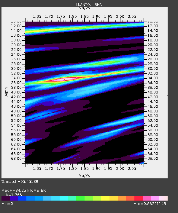
ANTO Ankara, Turkey - Earthquake Result Viewer

Earthquake location: Minahassa Peninsula, Sulawesi
Earthquake latitude/longitude: 0.7/120.0
Earthquake time(UTC): 1996/01/01 (001) 08:05:11 GMT
Earthquake Depth: 33 km
Earthquake Magnitude: 6.2 MB, 7.7 MS, 7.8 UNKNOWN, 7.8 MW
Earthquake Catalog/Contributor: WHDF/NEIC
Network: IU Global Seismograph Network (GSN - IRIS/USGS)
Station: ANTO Ankara, Turkey
Lat/Lon: 39.87 N/32.79 E
Elevation: 883 m
Distance: 87.4 deg
Az: 309.69 deg
Baz: 91.243 deg
Ray Param: 0.043328
Estimated Moho Depth: 34.25 km
Estimated Crust Vp/Vs: 1.76
Assumed Crust Vp: 6.159 km/s
Estimated Crust Vs: 3.489 km/s
Estimated Crust Poisson's Ratio: 0.26
Radial Match: 95.45139 %
Radial Bump: 356
Transverse Match: 86.00154 %
Transverse Bump: 400
SOD ConfigId: 6273
Insert Time: 2010-03-03 14:03:37.730 +0000
GWidth: 2.5
Max Bumps: 400
Tol: 0.001

Signal To Noise

ChannelStoNSTALTA
IU:ANTO: :BHN:19960101T08:17:24.451025Z1.31405211.2953636E-79.857779E-8
IU:ANTO: :BHE:19960101T08:17:24.451025Z3.38432484.228659E-71.2494839E-7
IU:ANTO: :BHZ:19960101T08:17:24.451025Z5.11616231.2205936E-62.3857604E-7
Arrivals
Ps4.3 SECOND
PpPs15 SECOND
PsPs/PpSs19 SECOND