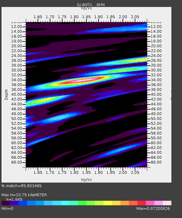
ANTO Ankara, Turkey - Earthquake Result Viewer
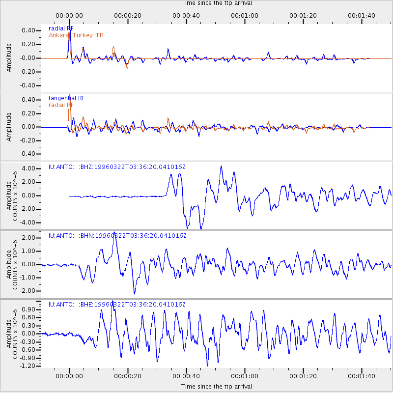
Earthquake location: Rat Islands, Aleutian Islands
Earthquake latitude/longitude: 51.2/178.7
Earthquake time(UTC): 1996/03/22 (082) 03:24:20 GMT
Earthquake Depth: 20 km
Earthquake Magnitude: 5.7 MB, 6.6 MS, 6.8 UNKNOWN, 6.6 ML
Earthquake Catalog/Contributor: WHDF/NEIC
Network: IU Global Seismograph Network (GSN - IRIS/USGS)
Station: ANTO Ankara, Turkey
Lat/Lon: 39.87 N/32.79 E
Elevation: 883 m
Distance: 84.5 deg
Az: 334.313 deg
Baz: 20.743 deg
Ray Param: 0.045412723
Estimated Moho Depth: 33.75 km
Estimated Crust Vp/Vs: 1.85
Assumed Crust Vp: 6.159 km/s
Estimated Crust Vs: 3.338 km/s
Estimated Crust Poisson's Ratio: 0.29
Radial Match: 95.903465 %
Radial Bump: 400
Transverse Match: 91.110085 %
Transverse Bump: 400
SOD ConfigId: 6273
Insert Time: 2010-03-03 14:03:44.126 +0000
GWidth: 2.5
Max Bumps: 400
Tol: 0.001

Signal To Noise

ChannelStoNSTALTA
IU:ANTO: :BHN:19960322T03:36:20.041016Z7.8139683.6296495E-74.6450786E-8
IU:ANTO: :BHE:19960322T03:36:20.041016Z2.40164289.4423E-83.9316006E-8
IU:ANTO: :BHZ:19960322T03:36:20.041016Z24.4444331.1588685E-64.7408278E-8
Arrivals
Ps4.7 SECOND
PpPs15 SECOND
PsPs/PpSs20 SECOND