You are here: Home > Network List > IU - Global Seismograph Network (GSN - IRIS/USGS) Stations List
> Station ANTO Ankara, Turkey > Earthquake Result Viewer
ANTO Ankara, Turkey - Earthquake Result Viewer

| Earthquake location: |
Mindanao, Philippines |
| Earthquake latitude/longitude: |
9.5/126.3 |
| Earthquake time(UTC): |
1996/09/20 (264) 04:10:27 GMT |
| Earthquake Depth: |
33 km |
| Earthquake Magnitude: |
5.8 MB, 6.4 MS, 6.6 UNKNOWN, 6.6 MW |
| Earthquake Catalog/Contributor: |
WHDF/NEIC |
|
| Network: |
IU Global Seismograph Network (GSN - IRIS/USGS) |
| Station: |
ANTO Ankara, Turkey |
| Lat/Lon: |
39.87 N/32.79 E |
| Elevation: |
883 m |
|
| Distance: |
86.7 deg |
| Az: |
309.691 deg |
| Baz: |
80.541 deg |
| Ray Param: |
0.043839127 |
| Estimated Moho Depth: |
30.75 km |
| Estimated Crust Vp/Vs: |
2.00 |
| Assumed Crust Vp: |
6.159 km/s |
| Estimated Crust Vs: |
3.076 km/s |
| Estimated Crust Poisson's Ratio: |
0.33 |
|
| Radial Match: |
89.842255 % |
| Radial Bump: |
400 |
| Transverse Match: |
83.63367 % |
| Transverse Bump: |
400 |
| SOD ConfigId: |
6273 |
| Insert Time: |
2010-03-03 14:03:51.297 +0000 |
| GWidth: |
2.5 |
| Max Bumps: |
400 |
| Tol: |
0.001 |
|
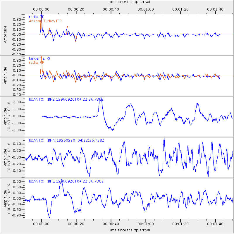
Signal To Noise
| Channel | StoN | STA | LTA |
| IU:ANTO: :BHN:19960920T04:22:36.738Z | 2.0035584 | 8.083022E-8 | 4.034333E-8 |
| IU:ANTO: :BHE:19960920T04:22:36.738Z | 6.6616926 | 4.3302887E-7 | 6.500283E-8 |
| IU:ANTO: :BHZ:19960920T04:22:36.738Z | 21.233274 | 1.4112857E-6 | 6.646576E-8 |
| Arrivals |
| Ps | 5.1 SECOND |
| PpPs | 15 SECOND |
| PsPs/PpSs | 20 SECOND |


