ANTO Ankara, Turkey - Earthquake Result Viewer
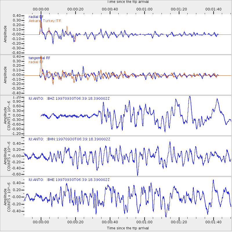
Earthquake location: Southeast Of Honshu, Japan
Earthquake latitude/longitude: 32.0/141.9
Earthquake time(UTC): 1997/09/30 (273) 06:27:24 GMT
Earthquake Depth: 10 km
Earthquake Magnitude: 5.5 MB, 6.5 MS, 6.1 UNKNOWN, 6.0 MW
Earthquake Catalog/Contributor: WHDF/NEIC
Network: IU Global Seismograph Network (GSN - IRIS/USGS)
Station: ANTO Ankara, Turkey
Lat/Lon: 39.87 N/32.79 E
Elevation: 883 m
Distance: 83.0 deg
Az: 312.875 deg
Baz: 54.036 deg
Ray Param: 0.04651942
Estimated Moho Depth: 30.75 km
Estimated Crust Vp/Vs: 1.96
Assumed Crust Vp: 6.159 km/s
Estimated Crust Vs: 3.15 km/s
Estimated Crust Poisson's Ratio: 0.32
Radial Match: 90.12498 %
Radial Bump: 400
Transverse Match: 83.85717 %
Transverse Bump: 400
SOD ConfigId: 6273
Insert Time: 2010-03-03 14:04:02.843 +0000
GWidth: 2.5
Max Bumps: 400
Tol: 0.001

Signal To Noise

ChannelStoNSTALTA
IU:ANTO: :BHN:19970930T06:39:18.390002Z1.80846746.748561E-83.731646E-8
IU:ANTO: :BHE:19970930T06:39:18.390002Z1.45511625.955102E-84.092527E-8
IU:ANTO: :BHZ:19970930T06:39:18.390002Z2.33014851.5479239E-76.643027E-8
Arrivals
Ps4.9 SECOND
PpPs14 SECOND
PsPs/PpSs19 SECOND