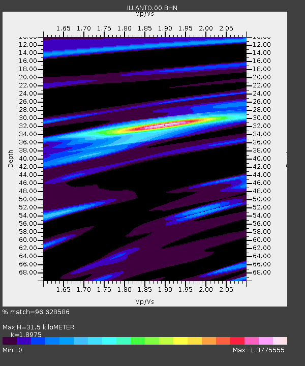
ANTO Ankara, Turkey - Earthquake Result Viewer
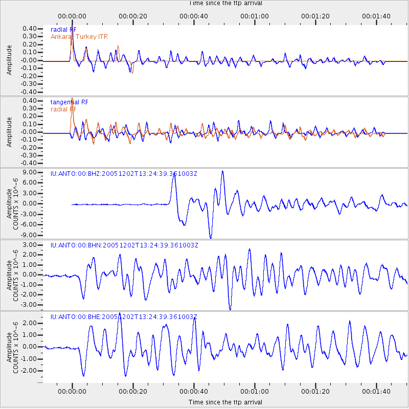
Earthquake location: Near East Coast Of Honshu, Japan
Earthquake latitude/longitude: 38.1/142.1
Earthquake time(UTC): 2005/12/02 (336) 13:13:09 GMT
Earthquake Depth: 29 km
Earthquake Magnitude: 6.1 MB, 6.3 MS, 6.5 MW, 6.4 MW
Earthquake Catalog/Contributor: WHDF/NEIC
Network: IU Global Seismograph Network (GSN - IRIS/USGS)
Station: ANTO Ankara, Turkey
Lat/Lon: 39.87 N/32.79 E
Elevation: 883 m
Distance: 79.0 deg
Az: 312.277 deg
Baz: 49.34 deg
Ray Param: 0.049240917
Estimated Moho Depth: 31.5 km
Estimated Crust Vp/Vs: 1.90
Assumed Crust Vp: 6.159 km/s
Estimated Crust Vs: 3.246 km/s
Estimated Crust Poisson's Ratio: 0.31
Radial Match: 96.628586 %
Radial Bump: 314
Transverse Match: 90.34027 %
Transverse Bump: 400
SOD ConfigId: 2422
Insert Time: 2010-03-03 14:04:23.820 +0000
GWidth: 2.5
Max Bumps: 400
Tol: 0.001

Signal To Noise

ChannelStoNSTALTA
IU:ANTO:00:BHN:20051202T13:24:39.361003Z13.093119.54721E-77.291782E-8
IU:ANTO:00:BHE:20051202T13:24:39.361003Z18.117811.0346158E-65.710491E-8
IU:ANTO:00:BHZ:20051202T13:24:39.361003Z51.0167473.8090752E-67.4663234E-8
Arrivals
Ps4.7 SECOND
PpPs14 SECOND
PsPs/PpSs19 SECOND