ANTO Ankara, Turkey - Earthquake Result Viewer
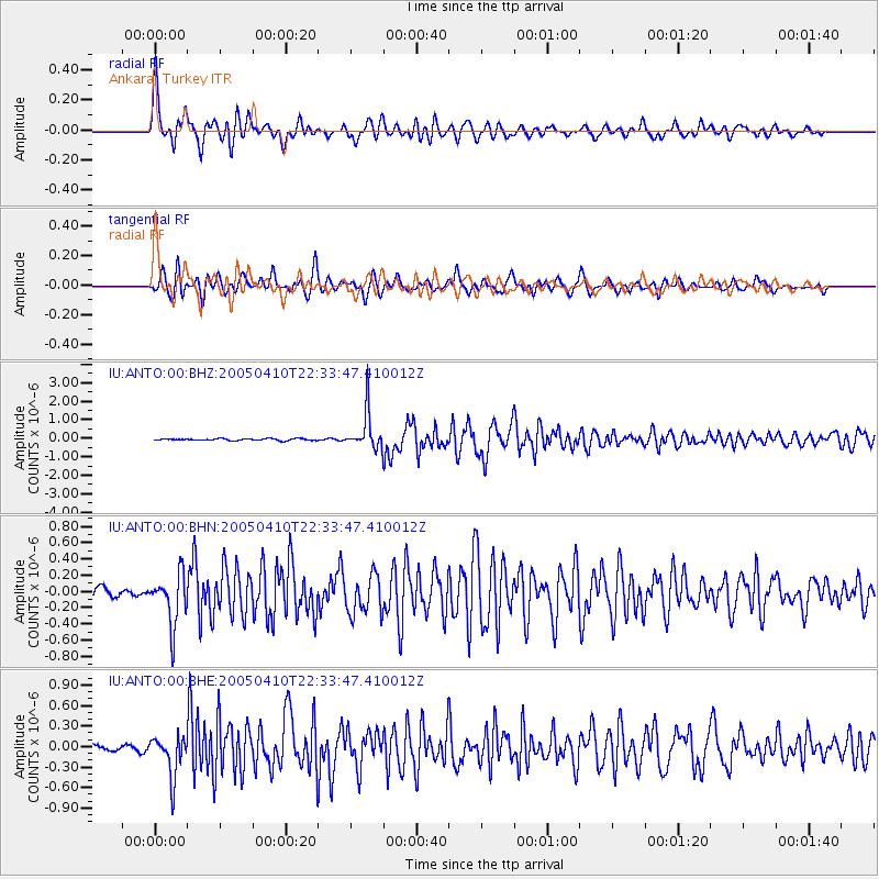
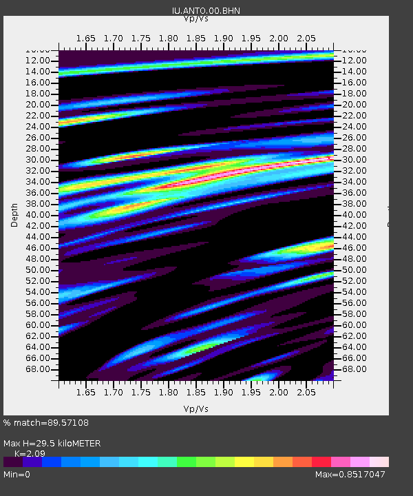
Earthquake location: Near East Coast Of Honshu, Japan
Earthquake latitude/longitude: 35.6/140.4
Earthquake time(UTC): 2005/04/10 (100) 22:22:15 GMT
Earthquake Depth: 43 km
Earthquake Magnitude: 6.1 MB, 5.4 MS, 6.0 MW, 6.0 MW
Earthquake Catalog/Contributor: WHDF/NEIC
Network: IU Global Seismograph Network (GSN - IRIS/USGS)
Station: ANTO Ankara, Turkey
Lat/Lon: 39.87 N/32.79 E
Elevation: 883 m
Distance: 79.6 deg
Az: 311.772 deg
Baz: 52.155 deg
Ray Param: 0.048772357
Estimated Moho Depth: 29.5 km
Estimated Crust Vp/Vs: 2.09
Assumed Crust Vp: 6.159 km/s
Estimated Crust Vs: 2.947 km/s
Estimated Crust Poisson's Ratio: 0.35
Radial Match: 89.57108 %
Radial Bump: 400
Transverse Match: 84.49904 %
Transverse Bump: 400
SOD ConfigId: 2459
Insert Time: 2010-03-03 14:04:40.716 +0000
GWidth: 2.5
Max Bumps: 400
Tol: 0.001

Signal To Noise

ChannelStoNSTALTA
IU:ANTO:00:BHN:20050410T22:33:47.410012Z4.47030973.1027062E-76.9406966E-8
IU:ANTO:00:BHE:20050410T22:33:47.410012Z5.06101662.9787452E-75.8856664E-8
IU:ANTO:00:BHZ:20050410T22:33:47.410012Z20.4148311.0191428E-64.9921688E-8
Arrivals
Ps5.3 SECOND
PpPs14 SECOND
PsPs/PpSs20 SECOND