You are here: Home > Network List > TA - USArray Transportable Network (new EarthScope stations) Stations List
> Station G59A Clarenceville, QC, USA > Earthquake Result Viewer
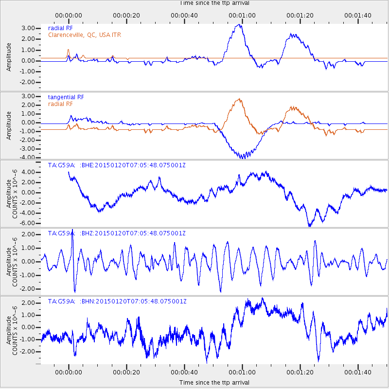
G59A Clarenceville, QC, USA - Earthquake Result Viewer
*The percent match for this event was below the threshold and hence no stack was calculated.
| Earthquake location: |
Mexico-Guatemala Border Region |
| Earthquake latitude/longitude: |
15.0/-91.3 |
| Earthquake time(UTC): |
2015/01/20 (020) 06:59:52 GMT |
| Earthquake Depth: |
162 km |
| Earthquake Magnitude: |
5.6 MB |
| Earthquake Catalog/Contributor: |
NEIC PDE/NEIC COMCAT |
|
| Network: |
TA USArray Transportable Network (new EarthScope stations) |
| Station: |
G59A Clarenceville, QC, USA |
| Lat/Lon: |
45.08 N/73.18 W |
| Elevation: |
36 m |
|
| Distance: |
33.7 deg |
| Az: |
23.47 deg |
| Baz: |
212.9 deg |
| Ray Param: |
$rayparam |
*The percent match for this event was below the threshold and hence was not used in the summary stack. |
|
| Radial Match: |
22.861172 % |
| Radial Bump: |
400 |
| Transverse Match: |
34.917088 % |
| Transverse Bump: |
400 |
| SOD ConfigId: |
837871 |
| Insert Time: |
2015-02-03 07:36:22.075 +0000 |
| GWidth: |
2.5 |
| Max Bumps: |
400 |
| Tol: |
0.001 |
|
Signal To Noise
| Channel | StoN | STA | LTA |
| TA:G59A: :BHZ:20150120T07:05:48.075001Z | 2.7184608 | 1.0716562E-6 | 3.9421437E-7 |
| TA:G59A: :BHN:20150120T07:05:48.075001Z | 1.1605747 | 6.082082E-6 | 5.240578E-6 |
| TA:G59A: :BHE:20150120T07:05:48.075001Z | 1.059526 | 1.9791746E-6 | 1.8679813E-6 |
| Arrivals |
| Ps | |
| PpPs | |
| PsPs/PpSs | |


