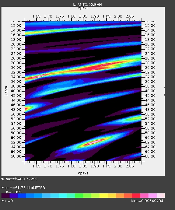
ANTO Ankara, Turkey - Earthquake Result Viewer
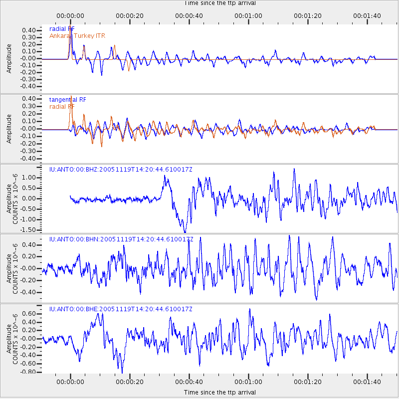
Earthquake location: Northern Sumatra, Indonesia
Earthquake latitude/longitude: 2.2/96.8
Earthquake time(UTC): 2005/11/19 (323) 14:10:13 GMT
Earthquake Depth: 21 km
Earthquake Magnitude: 6.0 MB, 6.1 MS, 6.5 MW, 6.5 MW
Earthquake Catalog/Contributor: WHDF/NEIC
Network: IU Global Seismograph Network (GSN - IRIS/USGS)
Station: ANTO Ankara, Turkey
Lat/Lon: 39.87 N/32.79 E
Elevation: 883 m
Distance: 68.8 deg
Az: 312.118 deg
Baz: 105.609 deg
Ray Param: 0.05602667
Estimated Moho Depth: 61.75 km
Estimated Crust Vp/Vs: 1.89
Assumed Crust Vp: 6.159 km/s
Estimated Crust Vs: 3.25 km/s
Estimated Crust Poisson's Ratio: 0.31
Radial Match: 89.77299 %
Radial Bump: 400
Transverse Match: 77.33548 %
Transverse Bump: 400
SOD ConfigId: 2448
Insert Time: 2010-03-03 14:04:46.433 +0000
GWidth: 2.5
Max Bumps: 400
Tol: 0.001

Signal To Noise

ChannelStoNSTALTA
IU:ANTO:00:BHN:20051119T14:20:44.610017Z1.42754351.0377805E-77.269694E-8
IU:ANTO:00:BHE:20051119T14:20:44.610017Z4.1110992.4249226E-75.898478E-8
IU:ANTO:00:BHZ:20051119T14:20:44.610017Z7.82590345.673895E-77.2501464E-8
Arrivals
Ps9.3 SECOND
PpPs28 SECOND
PsPs/PpSs37 SECOND