You are here: Home > Network List > TA - USArray Transportable Network (new EarthScope stations) Stations List
> Station G65A Princeton, ME, USA > Earthquake Result Viewer
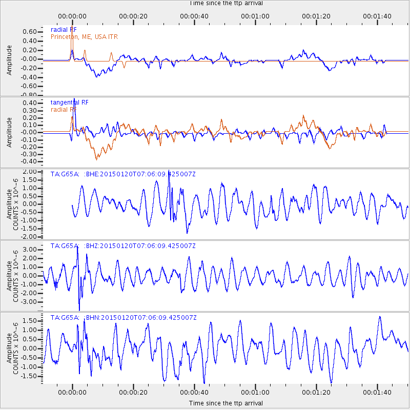
G65A Princeton, ME, USA - Earthquake Result Viewer
*The percent match for this event was below the threshold and hence no stack was calculated.
| Earthquake location: |
Mexico-Guatemala Border Region |
| Earthquake latitude/longitude: |
15.0/-91.3 |
| Earthquake time(UTC): |
2015/01/20 (020) 06:59:52 GMT |
| Earthquake Depth: |
162 km |
| Earthquake Magnitude: |
5.6 MB |
| Earthquake Catalog/Contributor: |
NEIC PDE/NEIC COMCAT |
|
| Network: |
TA USArray Transportable Network (new EarthScope stations) |
| Station: |
G65A Princeton, ME, USA |
| Lat/Lon: |
45.20 N/67.56 W |
| Elevation: |
78 m |
|
| Distance: |
36.2 deg |
| Az: |
28.884 deg |
| Baz: |
221.311 deg |
| Ray Param: |
$rayparam |
*The percent match for this event was below the threshold and hence was not used in the summary stack. |
|
| Radial Match: |
32.68901 % |
| Radial Bump: |
400 |
| Transverse Match: |
65.82943 % |
| Transverse Bump: |
400 |
| SOD ConfigId: |
837871 |
| Insert Time: |
2015-02-03 07:36:46.092 +0000 |
| GWidth: |
2.5 |
| Max Bumps: |
400 |
| Tol: |
0.001 |
|
Signal To Noise
| Channel | StoN | STA | LTA |
| TA:G65A: :BHZ:20150120T07:06:09.425007Z | 2.99146 | 1.6617064E-6 | 5.554834E-7 |
| TA:G65A: :BHN:20150120T07:06:09.425007Z | 1.2666652 | 6.58833E-7 | 5.2013195E-7 |
| TA:G65A: :BHE:20150120T07:06:09.425007Z | 1.5897199 | 7.65969E-7 | 4.8182636E-7 |
| Arrivals |
| Ps | |
| PpPs | |
| PsPs/PpSs | |


