You are here: Home > Network List > N4 - Central and EAstern US Network Stations List
> Station M44A Midewin, Midewin Nat. Tallgrass Prarie, IL, USA > Earthquake Result Viewer
M44A Midewin, Midewin Nat. Tallgrass Prarie, IL, USA - Earthquake Result Viewer
| Earthquake location: |
Off Coast Of Oregon |
| Earthquake latitude/longitude: |
44.5/-129.9 |
| Earthquake time(UTC): |
2015/06/01 (152) 20:11:31 GMT |
| Earthquake Depth: |
10 km |
| Earthquake Magnitude: |
5.9 MO |
| Earthquake Catalog/Contributor: |
NEIC PDE/NEIC ALERT |
|
| Network: |
N4 Central and EAstern US Network |
| Station: |
M44A Midewin, Midewin Nat. Tallgrass Prarie, IL, USA |
| Lat/Lon: |
41.39 N/88.04 W |
| Elevation: |
207 m |
|
| Distance: |
30.5 deg |
| Az: |
80.964 deg |
| Baz: |
290.041 deg |
| Ray Param: |
0.07930931 |
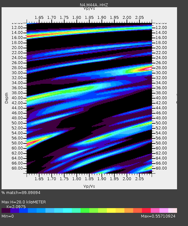
| Estimated Moho Depth: |
28.0 km |
| Estimated Crust Vp/Vs: |
2.10 |
| Assumed Crust Vp: |
6.498 km/s |
| Estimated Crust Vs: |
3.098 km/s |
| Estimated Crust Poisson's Ratio: |
0.35 |
|
| Radial Match: |
89.89894 % |
| Radial Bump: |
263 |
| Transverse Match: |
57.314323 % |
| Transverse Bump: |
400 |
| SOD ConfigId: |
7422571 |
| Insert Time: |
2019-04-19 04:45:25.578 +0000 |
| GWidth: |
2.5 |
| Max Bumps: |
400 |
| Tol: |
0.001 |
|

Signal To Noise
| Channel | StoN | STA | LTA |
| N4:M44A: :HHZ:20150601T20:17:13.970001Z | 10.335383 | 8.1651007E-7 | 7.900143E-8 |
| N4:M44A: :HHN:20150601T20:17:13.970001Z | 2.320001 | 2.6122274E-7 | 1.12595956E-7 |
| N4:M44A: :HHE:20150601T20:17:13.970001Z | 7.222958 | 6.1479466E-7 | 8.511674E-8 |
| Arrivals |
| Ps | 5.1 SECOND |
| PpPs | 12 SECOND |
| PsPs/PpSs | 18 SECOND |


