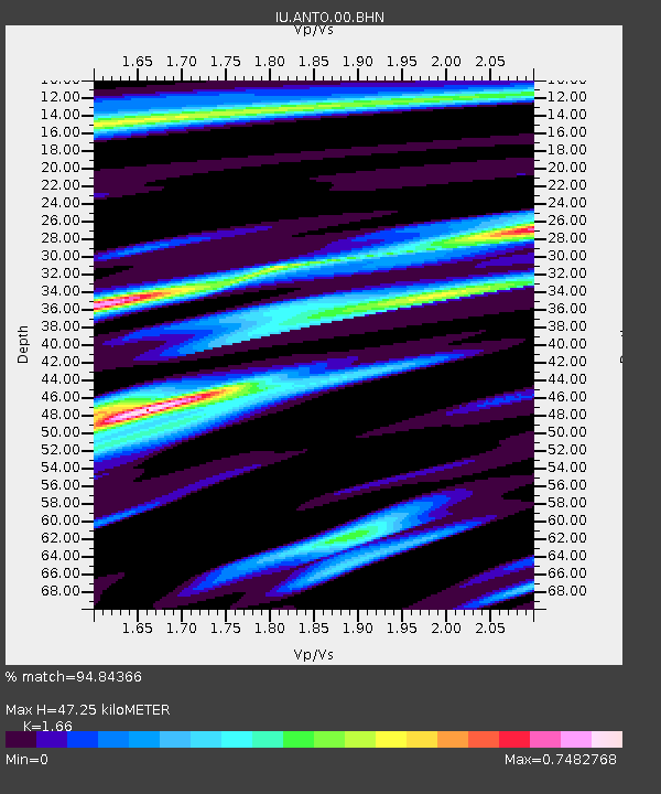
ANTO Ankara, Turkey - Earthquake Result Viewer
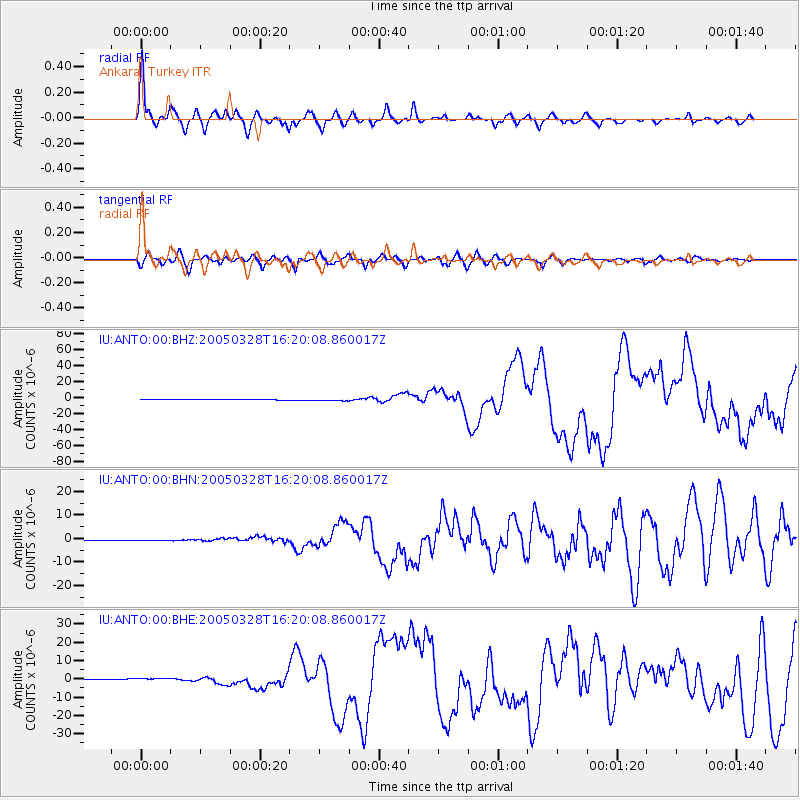
Earthquake location: Northern Sumatra, Indonesia
Earthquake latitude/longitude: 2.1/97.1
Earthquake time(UTC): 2005/03/28 (087) 16:09:36 GMT
Earthquake Depth: 30 km
Earthquake Magnitude: 7.2 MB, 8.4 MS, 8.7 MW, 8.1 MW
Earthquake Catalog/Contributor: WHDF/NEIC
Network: IU Global Seismograph Network (GSN - IRIS/USGS)
Station: ANTO Ankara, Turkey
Lat/Lon: 39.87 N/32.79 E
Elevation: 883 m
Distance: 69.1 deg
Az: 312.069 deg
Baz: 105.44 deg
Ray Param: 0.055815335
Estimated Moho Depth: 47.25 km
Estimated Crust Vp/Vs: 1.66
Assumed Crust Vp: 6.159 km/s
Estimated Crust Vs: 3.71 km/s
Estimated Crust Poisson's Ratio: 0.22
Radial Match: 94.84366 %
Radial Bump: 400
Transverse Match: 82.87506 %
Transverse Bump: 400
SOD ConfigId: 2459
Insert Time: 2010-03-03 14:05:08.617 +0000
GWidth: 2.5
Max Bumps: 400
Tol: 0.001

Signal To Noise

ChannelStoNSTALTA
IU:ANTO:00:BHN:20050328T16:20:08.860017Z1.65644448.966824E-85.4132958E-8
IU:ANTO:00:BHE:20050328T16:20:08.860017Z6.160676.0384417E-79.8015995E-8
IU:ANTO:00:BHZ:20050328T16:20:08.860017Z3.60243731.3403464E-63.7206655E-7
Arrivals
Ps5.3 SECOND
PpPs20 SECOND
PsPs/PpSs25 SECOND