You are here: Home > Network List > N4 - Central and EAstern US Network Stations List
> Station W57A Gilead, NC, USA > Earthquake Result Viewer
W57A Gilead, NC, USA - Earthquake Result Viewer
| Earthquake location: |
Off Coast Of Oregon |
| Earthquake latitude/longitude: |
44.5/-129.9 |
| Earthquake time(UTC): |
2015/06/01 (152) 20:11:31 GMT |
| Earthquake Depth: |
10 km |
| Earthquake Magnitude: |
5.9 MO |
| Earthquake Catalog/Contributor: |
NEIC PDE/NEIC ALERT |
|
| Network: |
N4 Central and EAstern US Network |
| Station: |
W57A Gilead, NC, USA |
| Lat/Lon: |
35.15 N/79.99 W |
| Elevation: |
85 m |
|
| Distance: |
38.9 deg |
| Az: |
86.224 deg |
| Baz: |
299.356 deg |
| Ray Param: |
0.075302824 |
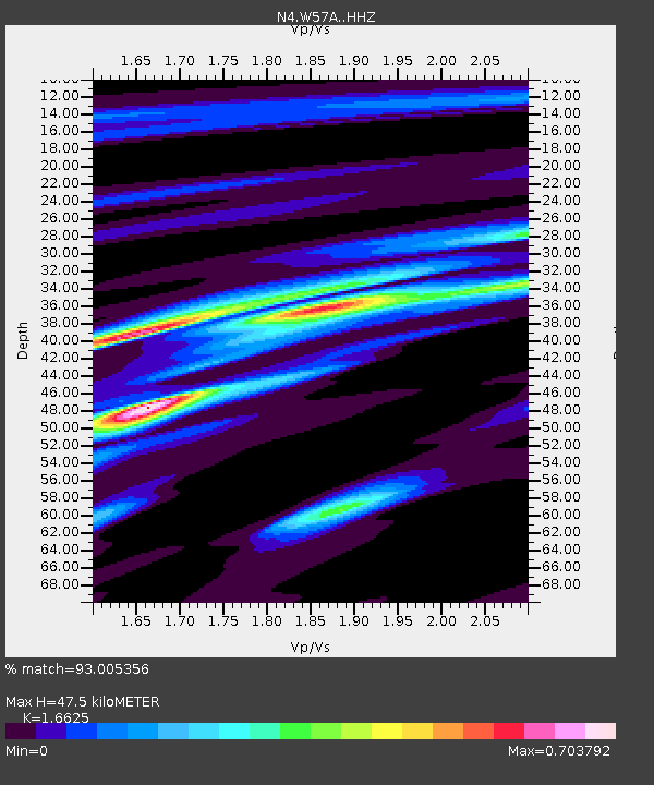
| Estimated Moho Depth: |
47.5 km |
| Estimated Crust Vp/Vs: |
1.66 |
| Assumed Crust Vp: |
6.565 km/s |
| Estimated Crust Vs: |
3.949 km/s |
| Estimated Crust Poisson's Ratio: |
0.22 |
|
| Radial Match: |
93.005356 % |
| Radial Bump: |
189 |
| Transverse Match: |
68.28965 % |
| Transverse Bump: |
400 |
| SOD ConfigId: |
7422571 |
| Insert Time: |
2019-04-19 04:46:06.029 +0000 |
| GWidth: |
2.5 |
| Max Bumps: |
400 |
| Tol: |
0.001 |
|

Signal To Noise
| Channel | StoN | STA | LTA |
| N4:W57A: :HHZ:20150601T20:18:25.980011Z | 5.3457646 | 4.792412E-7 | 8.9648765E-8 |
| N4:W57A: :HHN:20150601T20:18:25.980011Z | 3.3103814 | 2.0508551E-7 | 6.195223E-8 |
| N4:W57A: :HHE:20150601T20:18:25.980011Z | 5.0551906 | 3.0570914E-7 | 6.047431E-8 |
| Arrivals |
| Ps | 5.2 SECOND |
| PpPs | 18 SECOND |
| PsPs/PpSs | 23 SECOND |


