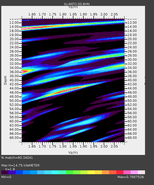
ANTO Ankara, Turkey - Earthquake Result Viewer
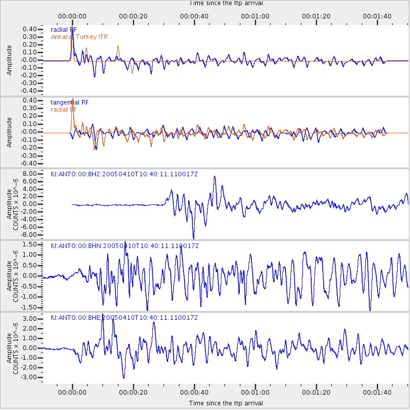
Earthquake location: Southern Sumatra, Indonesia
Earthquake latitude/longitude: -1.6/99.6
Earthquake time(UTC): 2005/04/10 (100) 10:29:11 GMT
Earthquake Depth: 19 km
Earthquake Magnitude: 6.4 MB, 6.7 MS, 6.7 MW, 6.6 MW
Earthquake Catalog/Contributor: WHDF/NEIC
Network: IU Global Seismograph Network (GSN - IRIS/USGS)
Station: ANTO Ankara, Turkey
Lat/Lon: 39.87 N/32.79 E
Elevation: 883 m
Distance: 73.5 deg
Az: 312.438 deg
Baz: 106.56 deg
Ray Param: 0.052972637
Estimated Moho Depth: 14.75 km
Estimated Crust Vp/Vs: 1.60
Assumed Crust Vp: 6.159 km/s
Estimated Crust Vs: 3.849 km/s
Estimated Crust Poisson's Ratio: 0.18
Radial Match: 90.34041 %
Radial Bump: 400
Transverse Match: 81.11704 %
Transverse Bump: 400
SOD ConfigId: 2459
Insert Time: 2010-03-03 14:05:17.234 +0000
GWidth: 2.5
Max Bumps: 400
Tol: 0.001

Signal To Noise

ChannelStoNSTALTA
IU:ANTO:00:BHN:20050410T10:40:11.110017Z2.52288171.7600058E-76.9761725E-8
IU:ANTO:00:BHE:20050410T10:40:11.110017Z10.1448346.2335454E-76.144552E-8
IU:ANTO:00:BHZ:20050410T10:40:11.110017Z23.8758871.8618109E-67.7978704E-8
Arrivals
Ps1.5 SECOND
PpPs6.0 SECOND
PsPs/PpSs7.5 SECOND