You are here: Home > Network List > N4 - Central and EAstern US Network Stations List
> Station Z47B Carrollton, AL, USA > Earthquake Result Viewer
Z47B Carrollton, AL, USA - Earthquake Result Viewer
| Earthquake location: |
Off Coast Of Oregon |
| Earthquake latitude/longitude: |
44.5/-129.9 |
| Earthquake time(UTC): |
2015/06/01 (152) 20:11:31 GMT |
| Earthquake Depth: |
10 km |
| Earthquake Magnitude: |
5.9 MO |
| Earthquake Catalog/Contributor: |
NEIC PDE/NEIC ALERT |
|
| Network: |
N4 Central and EAstern US Network |
| Station: |
Z47B Carrollton, AL, USA |
| Lat/Lon: |
33.20 N/88.07 W |
| Elevation: |
64 m |
|
| Distance: |
34.1 deg |
| Az: |
94.763 deg |
| Baz: |
301.709 deg |
| Ray Param: |
0.0779043 |
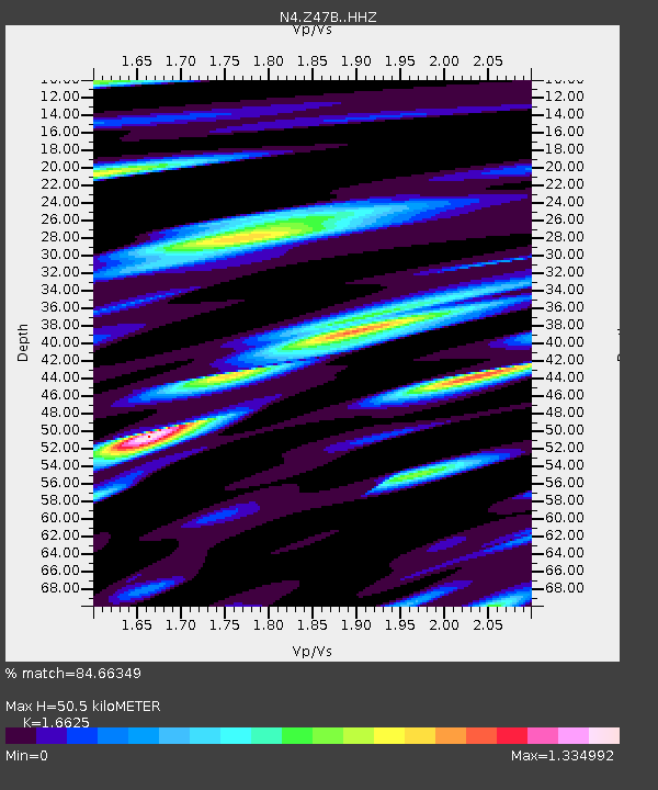
| Estimated Moho Depth: |
50.5 km |
| Estimated Crust Vp/Vs: |
1.66 |
| Assumed Crust Vp: |
6.201 km/s |
| Estimated Crust Vs: |
3.73 km/s |
| Estimated Crust Poisson's Ratio: |
0.22 |
|
| Radial Match: |
84.66349 % |
| Radial Bump: |
397 |
| Transverse Match: |
54.45867 % |
| Transverse Bump: |
400 |
| SOD ConfigId: |
7422571 |
| Insert Time: |
2019-04-19 04:46:13.466 +0000 |
| GWidth: |
2.5 |
| Max Bumps: |
400 |
| Tol: |
0.001 |
|

Signal To Noise
| Channel | StoN | STA | LTA |
| N4:Z47B: :HHZ:20150601T20:17:45.26001Z | 4.71112 | 5.063753E-7 | 1.07485114E-7 |
| N4:Z47B: :HHN:20150601T20:17:45.26001Z | 2.5112612 | 2.4027224E-7 | 9.567792E-8 |
| N4:Z47B: :HHE:20150601T20:17:45.26001Z | 2.8550246 | 3.602321E-7 | 1.2617477E-7 |
| Arrivals |
| Ps | 5.8 SECOND |
| PpPs | 20 SECOND |
| PsPs/PpSs | 26 SECOND |


