You are here: Home > Network List > TA - USArray Transportable Network (new EarthScope stations) Stations List
> Station H58A Gabriels, NY, USA > Earthquake Result Viewer
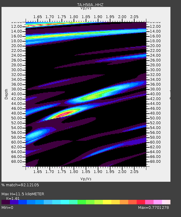
H58A Gabriels, NY, USA - Earthquake Result Viewer
| Earthquake location: |
Off Coast Of Oregon |
| Earthquake latitude/longitude: |
44.5/-129.9 |
| Earthquake time(UTC): |
2015/06/01 (152) 20:11:31 GMT |
| Earthquake Depth: |
10 km |
| Earthquake Magnitude: |
5.9 MO |
| Earthquake Catalog/Contributor: |
NEIC PDE/NEIC ALERT |
|
| Network: |
TA USArray Transportable Network (new EarthScope stations) |
| Station: |
H58A Gabriels, NY, USA |
| Lat/Lon: |
44.42 N/74.18 W |
| Elevation: |
537 m |
|
| Distance: |
39.1 deg |
| Az: |
69.861 deg |
| Baz: |
290.321 deg |
| Ray Param: |
0.07519469 |
| Estimated Moho Depth: |
11.5 km |
| Estimated Crust Vp/Vs: |
1.61 |
| Assumed Crust Vp: |
6.419 km/s |
| Estimated Crust Vs: |
3.987 km/s |
| Estimated Crust Poisson's Ratio: |
0.19 |
|
| Radial Match: |
92.12105 % |
| Radial Bump: |
261 |
| Transverse Match: |
65.9321 % |
| Transverse Bump: |
400 |
| SOD ConfigId: |
7422571 |
| Insert Time: |
2019-04-19 04:47:28.862 +0000 |
| GWidth: |
2.5 |
| Max Bumps: |
400 |
| Tol: |
0.001 |
|

Signal To Noise
| Channel | StoN | STA | LTA |
| TA:H58A: :HHZ:20150601T20:18:27.410004Z | 3.2817955 | 6.2600594E-7 | 1.9075105E-7 |
| TA:H58A: :HHN:20150601T20:18:27.410004Z | 1.1599008 | 1.637876E-7 | 1.412083E-7 |
| TA:H58A: :HHE:20150601T20:18:27.410004Z | 3.0605114 | 4.1399977E-7 | 1.3527143E-7 |
| Arrivals |
| Ps | 1.2 SECOND |
| PpPs | 4.3 SECOND |
| PsPs/PpSs | 5.5 SECOND |


