You are here: Home > Network List > TA - USArray Transportable Network (new EarthScope stations) Stations List
> Station H60A Morristown, VT, USA > Earthquake Result Viewer
H60A Morristown, VT, USA - Earthquake Result Viewer
| Earthquake location: |
Off Coast Of Oregon |
| Earthquake latitude/longitude: |
44.5/-129.9 |
| Earthquake time(UTC): |
2015/06/01 (152) 20:11:31 GMT |
| Earthquake Depth: |
10 km |
| Earthquake Magnitude: |
5.9 MO |
| Earthquake Catalog/Contributor: |
NEIC PDE/NEIC ALERT |
|
| Network: |
TA USArray Transportable Network (new EarthScope stations) |
| Station: |
H60A Morristown, VT, USA |
| Lat/Lon: |
44.56 N/72.70 W |
| Elevation: |
459 m |
|
| Distance: |
40.0 deg |
| Az: |
69.067 deg |
| Baz: |
290.743 deg |
| Ray Param: |
0.074640214 |
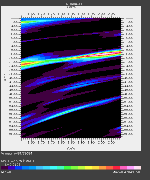
| Estimated Moho Depth: |
27.75 km |
| Estimated Crust Vp/Vs: |
2.01 |
| Assumed Crust Vp: |
6.419 km/s |
| Estimated Crust Vs: |
3.19 km/s |
| Estimated Crust Poisson's Ratio: |
0.34 |
|
| Radial Match: |
89.53084 % |
| Radial Bump: |
371 |
| Transverse Match: |
61.990105 % |
| Transverse Bump: |
400 |
| SOD ConfigId: |
7422571 |
| Insert Time: |
2019-04-19 04:47:29.933 +0000 |
| GWidth: |
2.5 |
| Max Bumps: |
400 |
| Tol: |
0.001 |
|

Signal To Noise
| Channel | StoN | STA | LTA |
| TA:H60A: :HHZ:20150601T20:18:35.23999Z | 3.1896377 | 5.6219466E-7 | 1.7625659E-7 |
| TA:H60A: :HHN:20150601T20:18:35.23999Z | 1.8146462 | 3.037823E-7 | 1.6740579E-7 |
| TA:H60A: :HHE:20150601T20:18:35.23999Z | 2.1174533 | 3.8258221E-7 | 1.8068035E-7 |
| Arrivals |
| Ps | 4.7 SECOND |
| PpPs | 12 SECOND |
| PsPs/PpSs | 17 SECOND |


