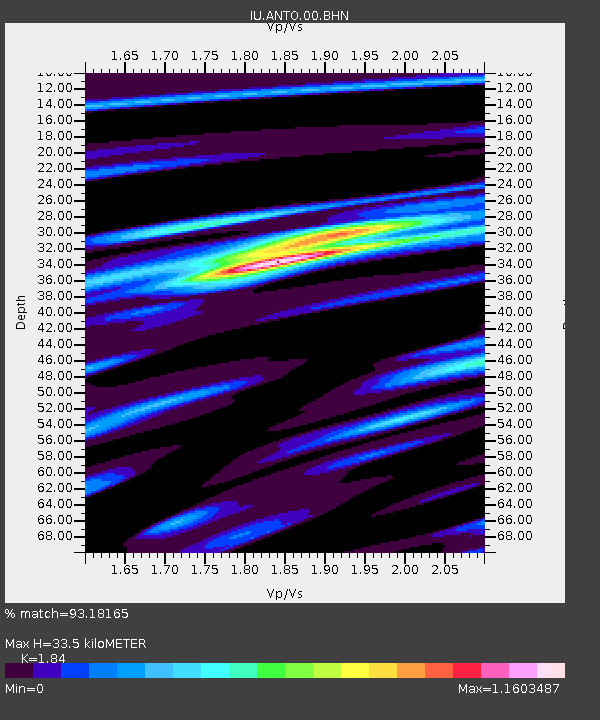
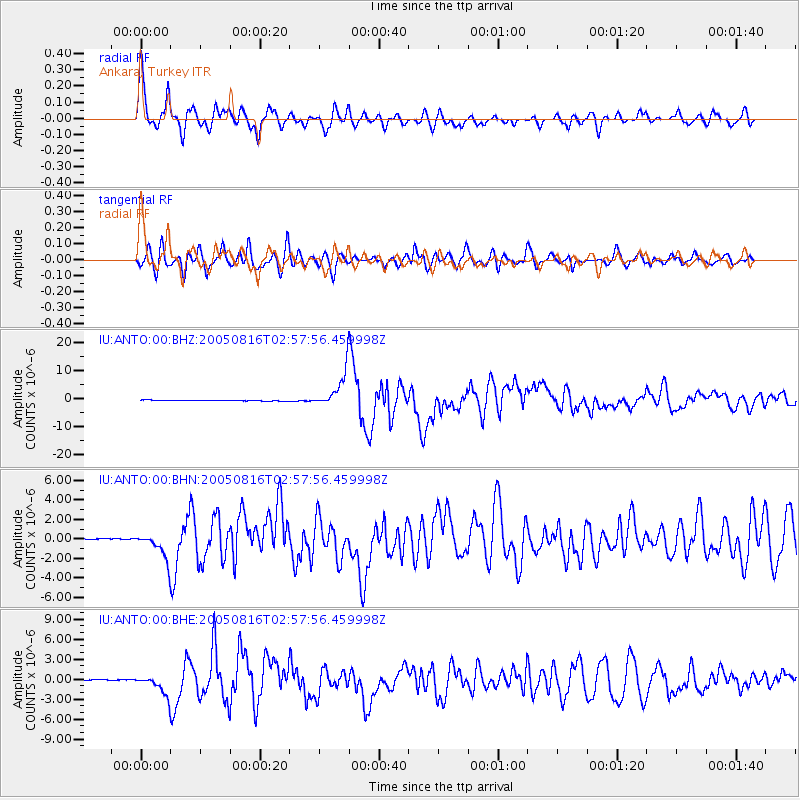
ANTO Ankara, Turkey - Earthquake Result Viewer

Earthquake location: Near East Coast Of Honshu, Japan
Earthquake latitude/longitude: 38.3/142.0
Earthquake time(UTC): 2005/08/16 (228) 02:46:28 GMT
Earthquake Depth: 36 km
Earthquake Magnitude: 6.5 MB, 6.8 MS, 7.2 MW, 7.1 MW
Earthquake Catalog/Contributor: WHDF/NEIC
Network: IU Global Seismograph Network (GSN - IRIS/USGS)
Station: ANTO Ankara, Turkey
Lat/Lon: 39.87 N/32.79 E
Elevation: 883 m
Distance: 78.8 deg
Az: 312.207 deg
Baz: 49.244 deg
Ray Param: 0.04934326
Estimated Moho Depth: 33.5 km
Estimated Crust Vp/Vs: 1.84
Assumed Crust Vp: 6.159 km/s
Estimated Crust Vs: 3.347 km/s
Estimated Crust Poisson's Ratio: 0.29
Radial Match: 93.18165 %
Radial Bump: 400
Transverse Match: 87.41342 %
Transverse Bump: 400
SOD ConfigId: 2475
Insert Time: 2010-03-03 14:05:50.070 +0000
GWidth: 2.5
Max Bumps: 400
Tol: 0.001

Signal To Noise

ChannelStoNSTALTA
IU:ANTO:00:BHN:20050816T02:57:56.459998Z20.8088551.3193142E-66.340157E-8
IU:ANTO:00:BHE:20050816T02:57:56.459998Z19.7889521.434562E-67.249308E-8
IU:ANTO:00:BHZ:20050816T02:57:56.459998Z44.784456.3706134E-61.4225056E-7
Arrivals
Ps4.7 SECOND
PpPs15 SECOND
PsPs/PpSs20 SECOND