You are here: Home > Network List > TA - USArray Transportable Network (new EarthScope stations) Stations List
> Station I64A Boothbay, ME, USA > Earthquake Result Viewer
I64A Boothbay, ME, USA - Earthquake Result Viewer
*The percent match for this event was below the threshold and hence no stack was calculated.
| Earthquake location: |
Off Coast Of Oregon |
| Earthquake latitude/longitude: |
44.5/-129.9 |
| Earthquake time(UTC): |
2015/06/01 (152) 20:11:31 GMT |
| Earthquake Depth: |
10 km |
| Earthquake Magnitude: |
5.9 MO |
| Earthquake Catalog/Contributor: |
NEIC PDE/NEIC ALERT |
|
| Network: |
TA USArray Transportable Network (new EarthScope stations) |
| Station: |
I64A Boothbay, ME, USA |
| Lat/Lon: |
43.92 N/69.63 W |
| Elevation: |
17 m |
|
| Distance: |
42.3 deg |
| Az: |
68.735 deg |
| Baz: |
292.623 deg |
| Ray Param: |
$rayparam |
*The percent match for this event was below the threshold and hence was not used in the summary stack. |
|
| Radial Match: |
74.18408 % |
| Radial Bump: |
396 |
| Transverse Match: |
72.792564 % |
| Transverse Bump: |
400 |
| SOD ConfigId: |
7422571 |
| Insert Time: |
2019-04-19 04:47:39.884 +0000 |
| GWidth: |
2.5 |
| Max Bumps: |
400 |
| Tol: |
0.001 |
|
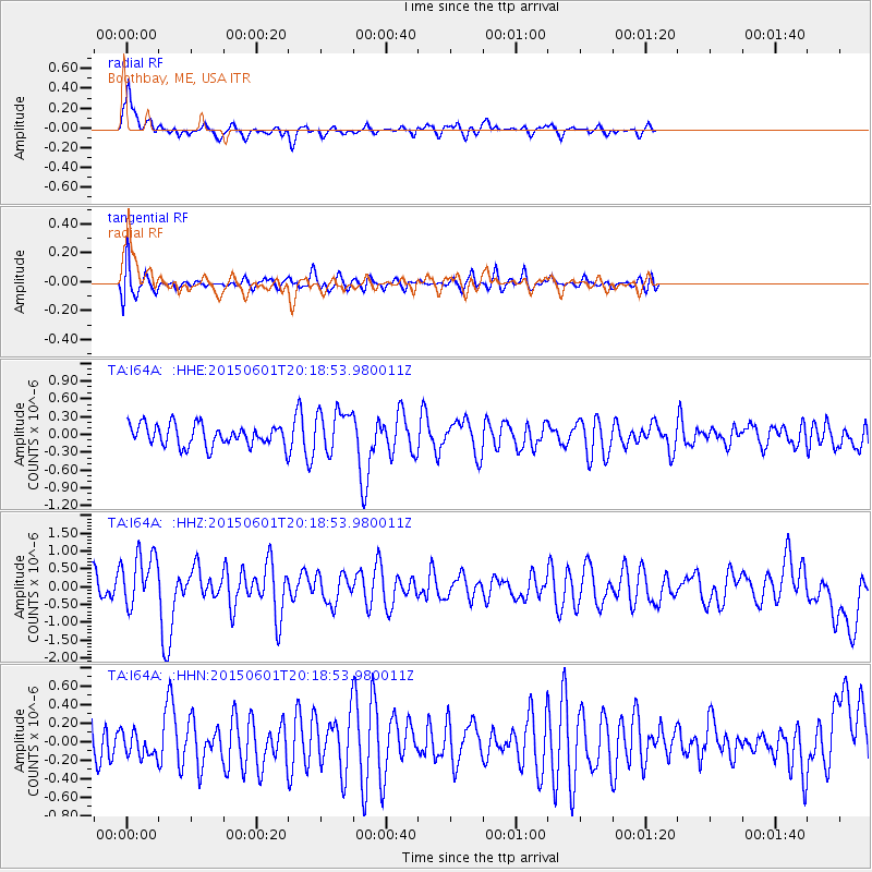
Signal To Noise
| Channel | StoN | STA | LTA |
| TA:I64A: :HHZ:20150601T20:18:53.980011Z | 1.5351067 | 7.472297E-7 | 4.8676077E-7 |
| TA:I64A: :HHN:20150601T20:18:53.980011Z | 0.439359 | 1.3861528E-7 | 3.1549433E-7 |
| TA:I64A: :HHE:20150601T20:18:53.980011Z | 2.032198 | 3.730443E-7 | 1.8356691E-7 |
| Arrivals |
| Ps | |
| PpPs | |
| PsPs/PpSs | |


