You are here: Home > Network List > TA - USArray Transportable Network (new EarthScope stations) Stations List
> Station L59A Walton, NY, USA > Earthquake Result Viewer
L59A Walton, NY, USA - Earthquake Result Viewer
| Earthquake location: |
Off Coast Of Oregon |
| Earthquake latitude/longitude: |
44.5/-129.9 |
| Earthquake time(UTC): |
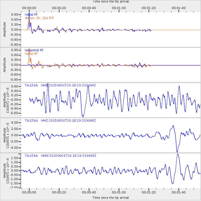
2015/06/01 (152) 20:11:31 GMT |
| Earthquake Depth: |
10 km |
| Earthquake Magnitude: |
5.9 MO |
| Earthquake Catalog/Contributor: |
NEIC PDE/NEIC ALERT |
|
| Network: |
TA USArray Transportable Network (new EarthScope stations) |
| Station: |
L59A Walton, NY, USA |
| Lat/Lon: |
42.19 N/75.04 W |
| Elevation: |
677 m |
|
| Distance: |
39.3 deg |
| Az: |
73.506 deg |
| Baz: |
292.556 deg |
| Ray Param: |
0.07506326 |
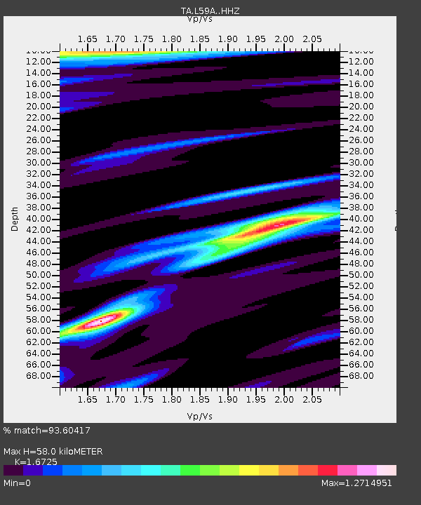
| Estimated Moho Depth: |
58.0 km |
| Estimated Crust Vp/Vs: |
1.67 |
| Assumed Crust Vp: |
6.419 km/s |
| Estimated Crust Vs: |
3.838 km/s |
| Estimated Crust Poisson's Ratio: |
0.22 |
|
| Radial Match: |
93.60417 % |
| Radial Bump: |
345 |
| Transverse Match: |
63.531654 % |
| Transverse Bump: |
400 |
| SOD ConfigId: |
7422571 |
| Insert Time: |
2019-04-19 04:47:53.307 +0000 |
| GWidth: |
2.5 |
| Max Bumps: |
400 |
| Tol: |
0.001 |
|
Signal To Noise
| Channel | StoN | STA | LTA |
| TA:L59A: :HHZ:20150601T20:18:29.339996Z | 1.6749926 | 5.716837E-7 | 3.4130522E-7 |
| TA:L59A: :HHN:20150601T20:18:29.339996Z | 0.84621924 | 1.4637615E-7 | 1.7297663E-7 |
| TA:L59A: :HHE:20150601T20:18:29.339996Z | 1.3399981 | 3.119461E-7 | 2.3279593E-7 |
| Arrivals |
| Ps | 6.6 SECOND |
| PpPs | 22 SECOND |
| PsPs/PpSs | 29 SECOND |


