You are here: Home > Network List > TA - USArray Transportable Network (new EarthScope stations) Stations List
> Station O48A Farmland, IN, USA > Earthquake Result Viewer
O48A Farmland, IN, USA - Earthquake Result Viewer
| Earthquake location: |
Off Coast Of Oregon |
| Earthquake latitude/longitude: |
44.5/-129.9 |
| Earthquake time(UTC): |
2015/06/01 (152) 20:11:31 GMT |
| Earthquake Depth: |
10 km |
| Earthquake Magnitude: |
5.9 MO |
| Earthquake Catalog/Contributor: |
NEIC PDE/NEIC ALERT |
|
| Network: |
TA USArray Transportable Network (new EarthScope stations) |
| Station: |
O48A Farmland, IN, USA |
| Lat/Lon: |
40.26 N/85.16 W |
| Elevation: |
300 m |
|
| Distance: |
33.0 deg |
| Az: |
81.46 deg |
| Baz: |
292.344 deg |
| Ray Param: |
0.078420654 |
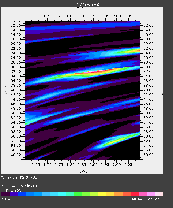
| Estimated Moho Depth: |
31.5 km |
| Estimated Crust Vp/Vs: |
1.90 |
| Assumed Crust Vp: |
6.498 km/s |
| Estimated Crust Vs: |
3.411 km/s |
| Estimated Crust Poisson's Ratio: |
0.31 |
|
| Radial Match: |
92.67733 % |
| Radial Bump: |
288 |
| Transverse Match: |
68.174484 % |
| Transverse Bump: |
400 |
| SOD ConfigId: |
7422571 |
| Insert Time: |
2019-04-19 04:48:00.523 +0000 |
| GWidth: |
2.5 |
| Max Bumps: |
400 |
| Tol: |
0.001 |
|
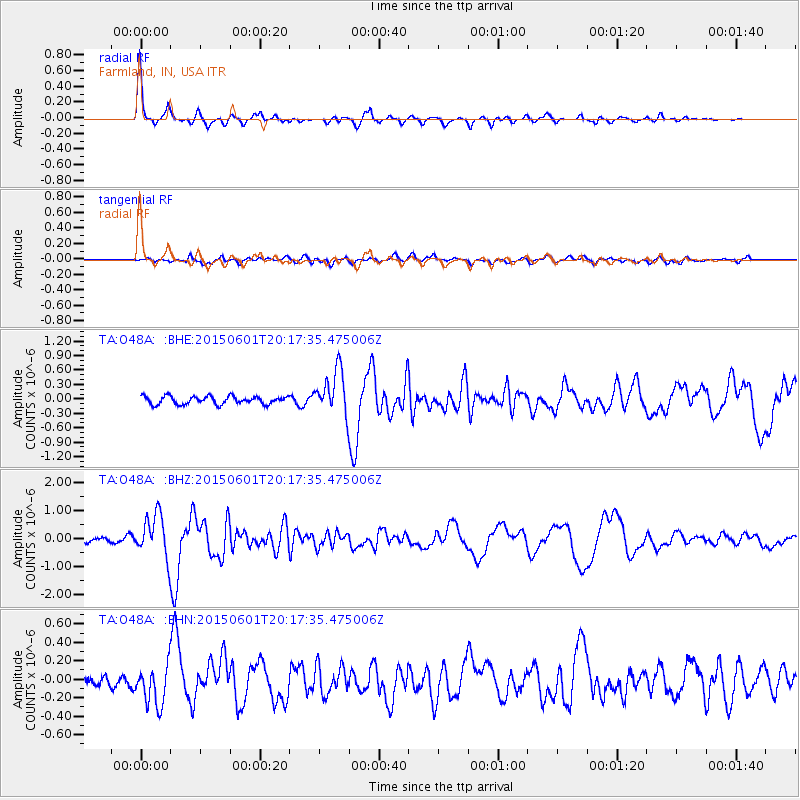
Signal To Noise
| Channel | StoN | STA | LTA |
| TA:O48A: :BHZ:20150601T20:17:35.475006Z | 7.958993 | 7.524204E-7 | 9.4537135E-8 |
| TA:O48A: :BHN:20150601T20:17:35.475006Z | 2.6975172 | 2.128065E-7 | 7.888976E-8 |
| TA:O48A: :BHE:20150601T20:17:35.475006Z | 5.948695 | 4.8917553E-7 | 8.223241E-8 |
| Arrivals |
| Ps | 4.7 SECOND |
| PpPs | 13 SECOND |
| PsPs/PpSs | 18 SECOND |


