You are here: Home > Network List > US - United States National Seismic Network Stations List
> Station EGMT Eagleton, Montana, USA > Earthquake Result Viewer
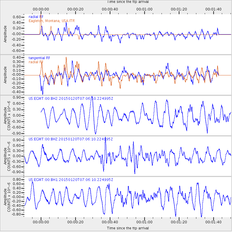
EGMT Eagleton, Montana, USA - Earthquake Result Viewer
*The percent match for this event was below the threshold and hence no stack was calculated.
| Earthquake location: |
Mexico-Guatemala Border Region |
| Earthquake latitude/longitude: |
15.0/-91.3 |
| Earthquake time(UTC): |
2015/01/20 (020) 06:59:52 GMT |
| Earthquake Depth: |
162 km |
| Earthquake Magnitude: |
5.6 MB |
| Earthquake Catalog/Contributor: |
NEIC PDE/NEIC COMCAT |
|
| Network: |
US United States National Seismic Network |
| Station: |
EGMT Eagleton, Montana, USA |
| Lat/Lon: |
48.02 N/109.75 W |
| Elevation: |
1055 m |
|
| Distance: |
36.3 deg |
| Az: |
338.988 deg |
| Baz: |
148.928 deg |
| Ray Param: |
$rayparam |
*The percent match for this event was below the threshold and hence was not used in the summary stack. |
|
| Radial Match: |
57.518642 % |
| Radial Bump: |
381 |
| Transverse Match: |
57.724354 % |
| Transverse Bump: |
370 |
| SOD ConfigId: |
837871 |
| Insert Time: |
2015-02-03 07:43:02.592 +0000 |
| GWidth: |
2.5 |
| Max Bumps: |
400 |
| Tol: |
0.001 |
|
Signal To Noise
| Channel | StoN | STA | LTA |
| US:EGMT:00:BHZ:20150120T07:06:10.224995Z | 1.8990836 | 3.3793174E-7 | 1.7794463E-7 |
| US:EGMT:00:BH1:20150120T07:06:10.224995Z | 0.69578594 | 1.999621E-7 | 2.8739026E-7 |
| US:EGMT:00:BH2:20150120T07:06:10.224995Z | 1.9844062 | 6.215019E-7 | 3.1319288E-7 |
| Arrivals |
| Ps | |
| PpPs | |
| PsPs/PpSs | |


