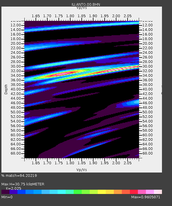
ANTO Ankara, Turkey - Earthquake Result Viewer
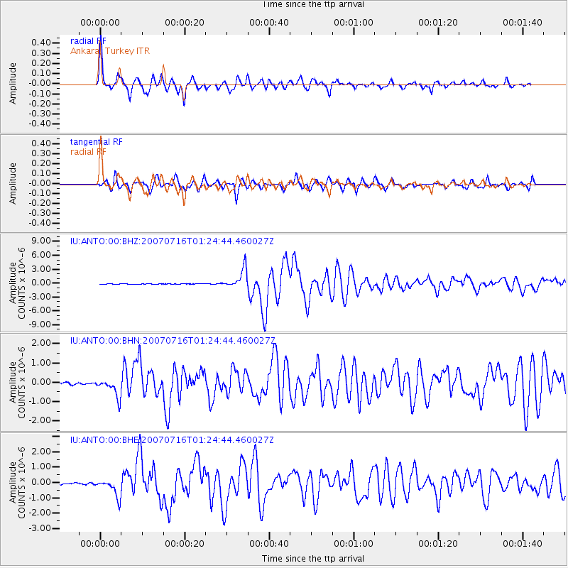
Earthquake location: Near West Coast Of Honshu, Japan
Earthquake latitude/longitude: 37.5/138.4
Earthquake time(UTC): 2007/07/16 (197) 01:13:22 GMT
Earthquake Depth: 12 km
Earthquake Magnitude: 6.5 MB, 6.4 MS, 6.6 MW, 6.5 MW
Earthquake Catalog/Contributor: WHDF/NEIC
Network: IU Global Seismograph Network (GSN - IRIS/USGS)
Station: ANTO Ankara, Turkey
Lat/Lon: 39.87 N/32.79 E
Elevation: 883 m
Distance: 77.2 deg
Az: 310.527 deg
Baz: 51.731 deg
Ray Param: 0.05050916
Estimated Moho Depth: 30.75 km
Estimated Crust Vp/Vs: 2.03
Assumed Crust Vp: 6.159 km/s
Estimated Crust Vs: 3.041 km/s
Estimated Crust Poisson's Ratio: 0.34
Radial Match: 94.20219 %
Radial Bump: 400
Transverse Match: 88.72098 %
Transverse Bump: 400
SOD ConfigId: 2564
Insert Time: 2010-03-03 14:06:40.070 +0000
GWidth: 2.5
Max Bumps: 400
Tol: 0.001

Signal To Noise

ChannelStoNSTALTA
IU:ANTO:00:BHN:20070716T01:24:44.460027Z8.7695064.8719306E-75.555536E-8
IU:ANTO:00:BHE:20070716T01:24:44.460027Z17.0499426.05459E-73.551091E-8
IU:ANTO:00:BHZ:20070716T01:24:44.460027Z77.716052.1394426E-62.7528966E-8
Arrivals
Ps5.2 SECOND
PpPs15 SECOND
PsPs/PpSs20 SECOND