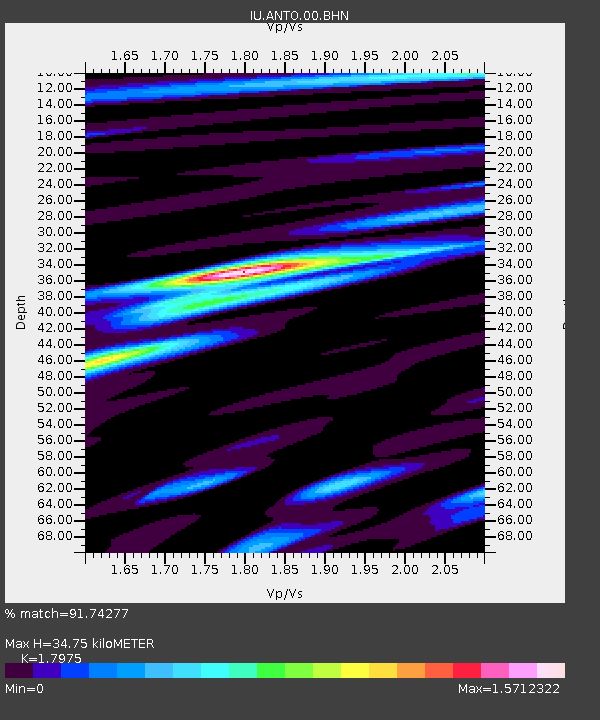
ANTO Ankara, Turkey - Earthquake Result Viewer
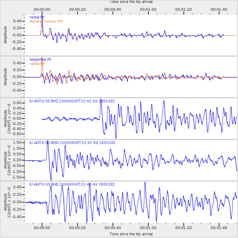
Earthquake location: Northern Mid-Atlantic Ridge
Earthquake latitude/longitude: 23.9/-46.1
Earthquake time(UTC): 2009/06/06 (157) 20:33:28 GMT
Earthquake Depth: 14 km
Earthquake Magnitude: 6.0 MB, 5.7 MS, 6.0 MW, 6.0 MW
Earthquake Catalog/Contributor: WHDF/NEIC
Network: IU Global Seismograph Network (GSN - IRIS/USGS)
Station: ANTO Ankara, Turkey
Lat/Lon: 39.87 N/32.79 E
Elevation: 883 m
Distance: 66.9 deg
Az: 55.198 deg
Baz: 282.372 deg
Ray Param: 0.057308815
Estimated Moho Depth: 34.75 km
Estimated Crust Vp/Vs: 1.80
Assumed Crust Vp: 6.159 km/s
Estimated Crust Vs: 3.426 km/s
Estimated Crust Poisson's Ratio: 0.28
Radial Match: 91.74277 %
Radial Bump: 400
Transverse Match: 88.92054 %
Transverse Bump: 400
SOD ConfigId: 2648
Insert Time: 2010-03-03 14:07:19.230 +0000
GWidth: 2.5
Max Bumps: 400
Tol: 0.001

Signal To Noise

ChannelStoNSTALTA
IU:ANTO:00:BHN:20090606T20:43:49.186018Z25.2766866.5980373E-72.6103253E-8
IU:ANTO:00:BHE:20090606T20:43:49.186018Z4.65039541.4281383E-73.0710044E-8
IU:ANTO:00:BHZ:20090606T20:43:49.186018Z8.5678632.8452936E-73.320891E-8
Arrivals
Ps4.7 SECOND
PpPs15 SECOND
PsPs/PpSs20 SECOND