ANTO Ankara, Turkey - Earthquake Result Viewer
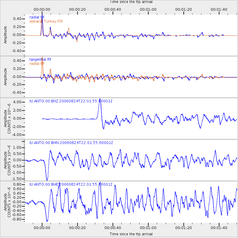
Earthquake location: Near East Coast Of Kamchatka
Earthquake latitude/longitude: 51.1/157.5
Earthquake time(UTC): 2006/08/24 (236) 21:50:36 GMT
Earthquake Depth: 43 km
Earthquake Magnitude: 5.9 MB, 6.2 MS, 6.5 MW, 6.5 MW
Earthquake Catalog/Contributor: WHDF/NEIC
Network: IU Global Seismograph Network (GSN - IRIS/USGS)
Station: ANTO Ankara, Turkey
Lat/Lon: 39.87 N/32.79 E
Elevation: 883 m
Distance: 77.3 deg
Az: 319.581 deg
Baz: 32.048 deg
Ray Param: 0.05034034
Estimated Moho Depth: 33.25 km
Estimated Crust Vp/Vs: 1.86
Assumed Crust Vp: 6.159 km/s
Estimated Crust Vs: 3.311 km/s
Estimated Crust Poisson's Ratio: 0.30
Radial Match: 91.96812 %
Radial Bump: 400
Transverse Match: 88.37692 %
Transverse Bump: 400
SOD ConfigId: 2564
Insert Time: 2010-03-03 14:08:07.681 +0000
GWidth: 2.5
Max Bumps: 400
Tol: 0.001

Signal To Noise

ChannelStoNSTALTA
IU:ANTO:00:BHN:20060824T22:01:55.66001Z21.8244747.465201E-73.4205637E-8
IU:ANTO:00:BHE:20060824T22:01:55.66001Z10.8318634.197055E-73.8747302E-8
IU:ANTO:00:BHZ:20060824T22:01:55.66001Z45.8475382.2418824E-64.889864E-8
Arrivals
Ps4.8 SECOND
PpPs15 SECOND
PsPs/PpSs20 SECOND