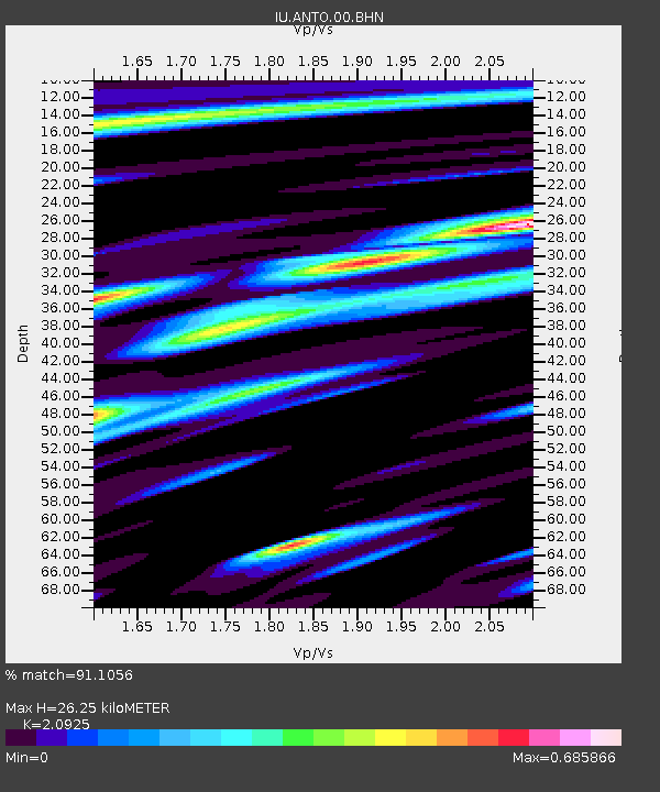
ANTO Ankara, Turkey - Earthquake Result Viewer
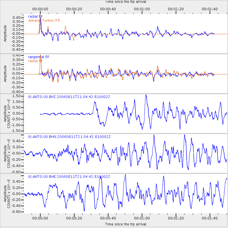
Earthquake location: Northern Sumatra, Indonesia
Earthquake latitude/longitude: 2.4/96.3
Earthquake time(UTC): 2006/08/11 (223) 20:54:14 GMT
Earthquake Depth: 22 km
Earthquake Magnitude: 5.8 MB, 6.2 MS, 6.2 MW, 6.1 MW
Earthquake Catalog/Contributor: WHDF/NEIC
Network: IU Global Seismograph Network (GSN - IRIS/USGS)
Station: ANTO Ankara, Turkey
Lat/Lon: 39.87 N/32.79 E
Elevation: 883 m
Distance: 68.3 deg
Az: 312.147 deg
Baz: 105.735 deg
Ray Param: 0.05634074
Estimated Moho Depth: 26.25 km
Estimated Crust Vp/Vs: 2.09
Assumed Crust Vp: 6.159 km/s
Estimated Crust Vs: 2.943 km/s
Estimated Crust Poisson's Ratio: 0.35
Radial Match: 91.1056 %
Radial Bump: 400
Transverse Match: 89.05859 %
Transverse Bump: 400
SOD ConfigId: 2564
Insert Time: 2010-03-03 14:08:14.551 +0000
GWidth: 2.5
Max Bumps: 400
Tol: 0.001

Signal To Noise

ChannelStoNSTALTA
IU:ANTO:00:BHN:20060811T21:04:42.810002Z1.84122018.187838E-84.4469633E-8
IU:ANTO:00:BHE:20060811T21:04:42.810002Z5.99661971.9527023E-73.256338E-8
IU:ANTO:00:BHZ:20060811T21:04:42.810002Z11.0905664.975399E-74.486154E-8
Arrivals
Ps4.8 SECOND
PpPs13 SECOND
PsPs/PpSs18 SECOND