You are here: Home > Network List > IU - Global Seismograph Network (GSN - IRIS/USGS) Stations List
> Station ANTO Ankara, Turkey > Earthquake Result Viewer
ANTO Ankara, Turkey - Earthquake Result Viewer
| Earthquake location: |
South Of Java, Indonesia |
| Earthquake latitude/longitude: |
-9.3/107.4 |
| Earthquake time(UTC): |
2006/07/17 (198) 08:19:28 GMT |
| Earthquake Depth: |
34 km |
| Earthquake Magnitude: |
6.1 MB, 7.2 MS, 7.7 MW, 7.2 MW |
| Earthquake Catalog/Contributor: |
WHDF/NEIC |
|
| Network: |
IU Global Seismograph Network (GSN - IRIS/USGS) |
| Station: |
ANTO Ankara, Turkey |
| Lat/Lon: |
39.87 N/32.79 E |
| Elevation: |
883 m |
|
| Distance: |
84.3 deg |
| Az: |
311.776 deg |
| Baz: |
106.954 deg |
| Ray Param: |
0.04554474 |
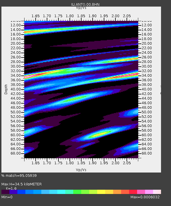
| Estimated Moho Depth: |
34.5 km |
| Estimated Crust Vp/Vs: |
1.60 |
| Assumed Crust Vp: |
6.159 km/s |
| Estimated Crust Vs: |
3.849 km/s |
| Estimated Crust Poisson's Ratio: |
0.18 |
|
| Radial Match: |
95.05939 % |
| Radial Bump: |
400 |
| Transverse Match: |
88.57582 % |
| Transverse Bump: |
400 |
| SOD ConfigId: |
5423 |
| Insert Time: |
2010-03-03 14:08:19.331 +0000 |
| GWidth: |
2.5 |
| Max Bumps: |
400 |
| Tol: |
0.001 |
|
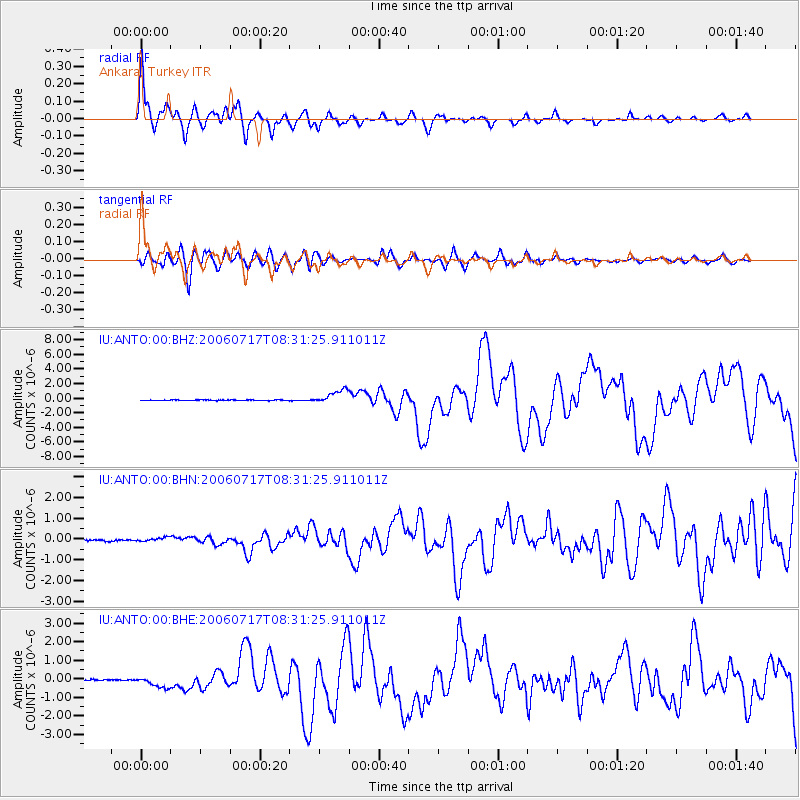
Signal To Noise
| Channel | StoN | STA | LTA |
| IU:ANTO:00:BHN:20060717T08:31:25.911011Z | 2.6009269 | 1.0350374E-7 | 3.9794944E-8 |
| IU:ANTO:00:BHE:20060717T08:31:25.911011Z | 9.26552 | 2.923971E-7 | 3.1557548E-8 |
| IU:ANTO:00:BHZ:20060717T08:31:25.911011Z | 20.92284 | 9.757796E-7 | 4.6637055E-8 |
| Arrivals |
| Ps | 3.4 SECOND |
| PpPs | 14 SECOND |
| PsPs/PpSs | 18 SECOND |


