You are here: Home > Network List > IU - Global Seismograph Network (GSN - IRIS/USGS) Stations List
> Station ANTO Ankara, Turkey > Earthquake Result Viewer
ANTO Ankara, Turkey - Earthquake Result Viewer
| Earthquake location: |
Kuril Islands |
| Earthquake latitude/longitude: |
46.5/153.2 |
| Earthquake time(UTC): |
2006/10/01 (274) 09:06:02 GMT |
| Earthquake Depth: |
19 km |
| Earthquake Magnitude: |
6.1 MB, 6.4 MS, 6.6 MW, 6.5 MW |
| Earthquake Catalog/Contributor: |
WHDF/NEIC |
|
| Network: |
IU Global Seismograph Network (GSN - IRIS/USGS) |
| Station: |
ANTO Ankara, Turkey |
| Lat/Lon: |
39.87 N/32.79 E |
| Elevation: |
883 m |
|
| Distance: |
78.9 deg |
| Az: |
317.463 deg |
| Baz: |
37.383 deg |
| Ray Param: |
0.049287066 |
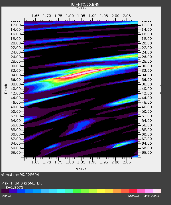
| Estimated Moho Depth: |
34.0 km |
| Estimated Crust Vp/Vs: |
1.81 |
| Assumed Crust Vp: |
6.159 km/s |
| Estimated Crust Vs: |
3.407 km/s |
| Estimated Crust Poisson's Ratio: |
0.28 |
|
| Radial Match: |
90.028694 % |
| Radial Bump: |
400 |
| Transverse Match: |
84.62184 % |
| Transverse Bump: |
400 |
| SOD ConfigId: |
2665 |
| Insert Time: |
2010-03-03 14:08:35.552 +0000 |
| GWidth: |
2.5 |
| Max Bumps: |
400 |
| Tol: |
0.001 |
|
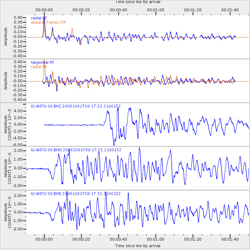
Signal To Noise
| Channel | StoN | STA | LTA |
| IU:ANTO:00:BHN:20061001T09:17:33.210015Z | 11.070387 | 5.235728E-7 | 4.7294893E-8 |
| IU:ANTO:00:BHE:20061001T09:17:33.210015Z | 9.079748 | 3.9610907E-7 | 4.362556E-8 |
| IU:ANTO:00:BHZ:20061001T09:17:33.210015Z | 41.260128 | 1.8762236E-6 | 4.547304E-8 |
| Arrivals |
| Ps | 4.6 SECOND |
| PpPs | 15 SECOND |
| PsPs/PpSs | 20 SECOND |


